I caught up with 12d Field Product Sales and Marketing Manager Graham Wirth to chat about Combined 12d Field.
This presentation reviews the improvements made to 12d Field in 12d Model 14.
Setout and Pickup have been combined into the one package to give the user more functionality, combined with a simpler user experience for all your survey needs.
Pickup’s new format enhances the user’s ability to manage complex string or point Attribute input to suit the needs of your clients. Setout has new functionality to further improve your productivity on site.
I caught up with Graeme Winfield of 12d Queensland to chat about some of the basics in 12d Model for Design.
In this video, Graeme covers such topics as:
Overview of 12d file and folder structures
The Design process
Survey data
Creating designs
Resolving 12d Model startup problems
Where to get more information
Catch up online today if you missed the live session!
Detailed Alignment Design adds another dimension to 12d® Model™, providing the tools to carry out the full range of civil design work, from land development to multi-lane highways with major intersections and exits.
Contact your local 12d Sales Team today for more information!
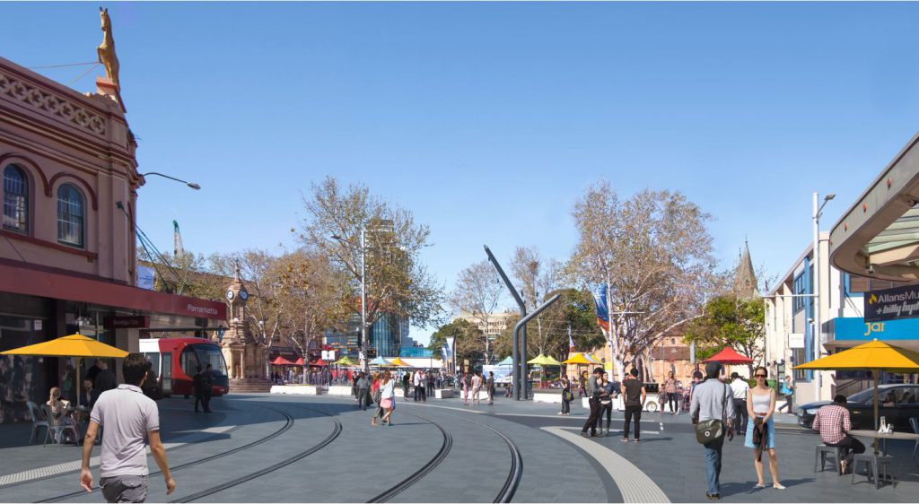
Arup Sydney’s entry in our Innovation Awards last year was truly fantastic. On the Parramatta Light Rail (Stage 1) project, they utilised 12d Model in innovative ways, bringing in all manner of applications not often seen before. The project worked on lots of different areas around Parramatta, requiring a lot of different solutions, and involved not just the design/construction of the light rail itself, but the enabling works that allowed the light rail to be built. In one section, they even needed to change a one-way street into a two-way street. It was a complex, multi-disciplinary project, and finding the right collaborative solution was essential. They spent time at the outset working this out, to great benefit.
We caught up with designers Jarred Dickson and Danny Wilcox to chat about their entry, which they submitted “to showcase the innovative things [they] were doing on the project,” and how this innovation helped the project.
To their team, ‘innovation’ meant ”doing something different”, “pushing the boundaries”, and finding new ways to do things. They did a lot of design verification checks – turning paths, sightline checks, etc. – in 12d Model (rather than externally as is usually the practice); this meant these aspects of the project could be in 3D rather than 2D as was previously the norm, and these could be reviewed as people were working on the design, rather than having to do this only at the end and having to go back and do rework. One of their favourite things about this was that 12d Model acted as a collaborative tool among all the different disciplines – it was the one true source model.
‘Digital Engineering’, to Arup, means doing everything digitally in one place. In the past, only half the design was in 3D and the rest was in 2D. On this project they only needed one drafter, and even she was working with them inside 12d Model. This meant not having to do much on paper at all. Collaboration meant everyone was working with the same tools, live. Not only did this benefit the team, the client (Transport for NSW) saw the benefits and was very pleased with the results. The team at Arup is confident that the time they spent setting this up will mean greatly improved efficiency across their future projects.
Danny told us that their previous workflow ‘would make a mess of a whiteboard’ – going back and forth between CAD and 12d Model, and with other disciplines (road design, structures, landscaping, urban design, etc.)…the old processes were very manual, very much on paper, and full of reviews and redesigns. Having it all in the model alleviated this, and the review process was so much easier – it could be done along the way, in 12d Model, visible in one 3D space. They thought there might be some resistance to this process being wholly digital, but actually the client was thrilled when they saw how much more efficient it was.
4D, 5D, and even 6D BIM came into this project. One section of roadworks had a very complex structure for a road widening, and they were able to create a full 4D design of how this road could remain open while the construction occurred, to minimise disruption in a busy area. Being able to increase efficiency (and reduce errors) in this regard allowed the teams to save a lot of money on this project. Future projects will also be more efficient through following the methods devised on this one.
MTFs, Snippets, and macros were some of the 12d Model tools that assisted these processes. Smart Snippets automated and streamlined the design process by enforcing the way things were modelled for consistency across the project. Danny mentioned that “the way 12d is set up to allow you to customise in-built panels with macros is pretty cool.” He said this project allowed them to take this kind of thing ‘to the next level’. The team also benefited from using Chains, because this gave them a way to describe new tools to others, and lay down how things work (including naming conventions) so the whole team can be ‘on the same page’. They can now bring these Chains into any project.
Vehicle Paths and Sight Lines computated within 12d Model have also been a new development – they used to be done in CAD, and this new method revolutionised processes. Trees, signage and more could be included in the 3D model. A register within 12d Model made this much easier to manage. For those who have trouble imagining 2D plans in 3D, this was incredibly helpful. Different ways to present utilities were devised, and these will be applied on many other projects over time.
The plan moving forward is to share these lessons and skills with others in the company – the small team involved in this project will be sharing ideas through the rest of Arup on Design Verification, Smart Snippets, and more.
This innovative work has set the standard for others to follow in future projects – this team has really ‘set the bar’, not just within Arup, but for the industry as a whole.
In this popular webinar video, Tim Brooks of 12d Queensland looks at using various Computators in 12d Model Super Alignments, and how these are used to create a more dynamic design.
Computators are used to link Alignments together. In Conjunction with Super Alignment Computators, Tim demonstrates how putting these into a Design Chain can significantly improve design project efficiency.
This presentation was produced in conjunction with one by Peter Taynton, also of 12d Queensland, about the Element Method and Super Alignment.
Contact us today on training@12d.com with your ideas for future 12d webinar topics!
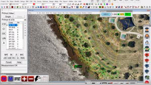
Over the years, Survey Managers such as Greg Cech of ESO Surveyors in Sydney have seen great changes in technology and in working practices across the industry. Tools such as software have opened doors in ways that once would have seemed impossible. When Greg started his career as a surveyor, he was working with what “…was basically a coordinate list that you used to type in and manually turn the jigger. Nowadays, we’re running 12d Field with fully robotic Leica equipment; it’s a different world completely.”
Greg has seen the industry move from teams of multiple surveyors down to what are often one-man teams, thanks to robotics. When he started, he was working in the country and that was usually a three-man team. He was just a field assistant back then, spending all his time clearing lines and helping with the manual calculations. Back then they used to just use standard computer aided design (CAD) packages, which weren’t ideal for survey work – they’re more drafting packages. Having a package that is intended for surveying is “a huge boon,” according to Greg, who started to use 12d Model software when he joined ESO. He found it an interesting challenge to update his skills in this way, as the packages he had used before were a lot more basic. With 12d Model, his initial thought was the shock at the size of it – he found himself going down multiple menus, finding new and improved ways to do things…which, as he became more proficient with it, wasn’t as daunting as it originally was.
Nowadays, at ESO, the jobs Greg is involved in tend to be quite complex; the simple jobs are mostly a thing of the past. He finds the more complex jobs much more simulating, commenting that, “It does get to the stage where just setting something out along a straight line is fairly monotonous, and it is good to stimulate your mind and learn how to do things a slightly different way.”
He has moved into the world of what the industry terms ‘BIM’ – building 3D models and setting out from the 3D models rather than just drawings and such. That’s a whole new skills-set that ESO has been building up over this last decade. Greg said it has its advantages because through being able to actually rotate an object in 3D, you can see any peaks and troughs. You can visually look at something and see if it’s correct. A lot of his calculations now are done graphically rather than mathematically. He finds that an easier way to check things, stating, “We can look at it and if we have to make an amendment to the design or something like that, the engineers can sit down with us, and the strings change be changed – we can show them what it will look like.” His team then gets the sign-off through the designers, and they are able to construct to that.
With the new techniques and all this melding technology, surveyors and the engineers are working much more closely than ever before. The engineers Greg works with have 12d Model licences as well, so they are able to get in and look at the models as well. Most of the time, engineers don’t have access to a CAD package, so they’re more reliant on surveyors to show them what the actual objects being constructed are going to look like and visually see any discrepancies or clashes. Greg feels that being able to see what’s going on more easily has helped engineers get a helpful idea on how things are supposed to fit together.
Dr Lee Gregory, CEO of 12d Solutions Pty Ltd (creators of 12d Model software), said, “I notice in some other work where people are picking up a lot more data as it is being built – especially underground services and such – that the construction firms, once they actually saw just how complex their jobs really were to show to the world, got very enthusiastic about seeing the 3D models of what they built.”
Greg agreed, saying, “With the services we have the GDPs, which are the dig permits. They all rely on the 3D modelling we do with 12d Model software.” He went on to state that “The paper plans just don’t have the detail anymore. They’re more an adjunct to the 3D model, the computer aided design work…They are more for details for fitments and things like that. Being able to construct a whole job through the paper plans would be difficult.”
Greg’s career has moved through the transition of 2D paper plans to a full 3D model – or BIM…he’s been seeing that trend starting to happen through the industry. He feels it’s “handy because anything that gives you more information is always better. You’re able to locate clashes that weren’t located before, or discrepancies between two plans.” He’s using it also for as-built or as-constructed pickups, so he’s able to see potential clashes – e.g. if things weren’t put in the right place – straightaway. His team uses 12d Field to compare the original model to the as-built model as they’re picking it up in the field – the 3D modelling is all happening right through the project, not just at the beginning. Lee commented, “I’ve waited 30 years for people to finally realise that services and things are important! I remember once in 1986 an engineer told me that it was often cheaper to move the roundabout or whatever than to move the services. So no one ever used to pick up the services.”
Greg responded, “Up here [on the Northern Beaches of Sydney], moving forward, new services will be better located; they’ll have a permanent record that can be passed on to anyone else doing work in the area, and that’ll make a huge difference.” This means they’re picking up most of those things now before they’re buried, and they have a full 3D proper model as it is, as constructed. That can then be handed back to the owners or to the various authorities so they can have it there for the future, to hopefully minimise future service strikes.
Through his career, Greg has seen trends move from three-man teams to one-man teams, and surveyors moving from just picking up shots to being data managers and controlling what’s going on from the construction side. He’s been watching the changes in technology, in the way things are done, in the type of job…going from total stations that measure distance that take a very a long time with two people, to robotic equipment, one-person teams, laser scanners, drones…he’s seen it a change a lot. ESO has some drones and some pilots. They’re all ancillary services now to what they provide; on the projects the client expects a broad range of services. This makes ESO a ‘one stop shop’. They’re managing a lot of the data for these clients. On some projects, they’re supporting the client’s survey resources as well as managing the data. This means they’ve had to start using more powerful computers. They’ve got some pretty powerful servers that control the backups for the whole company. They’ve found an online cloud system just doesn’t handle the size of the data that they’ve got. They’re managing a lot of that, including archiving, themselves, and keeping control of it.
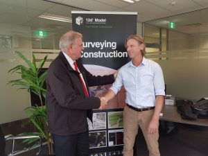
Campbell Blogg, General Manager of ESO Surveyors, has also seen the change from smaller three-man teams, down to one-man teams, and totally moving technology. There was a period when they went from two-person teams down to robotic and one-person teams quite quickly, and there were a lot of unhappy surveyors because they had to then do most of the manual work. Said Campbell, “It’s an unfortunate side effect. It’s always nice to have an assistant to help. But that’s just the way the industry evolved.”
12d CEO Dr Lee Gregory with ESO Surveyors General Manager Campbell Blogg
ESO has used technology in everything, to replace having two or three people and become more efficient. As a result, they’re more efficient, and their clients see the benefit of that. With 65 people, they’re doing the work of what might’ve been 180 people, years ago. The production that they put out now is far greater than 15 years ago. The surveyor’s role has massively increased productivity and helped their clients. A lot of projects now are even pegless – just feeding data to machine control and checking it. ESO was involved in the Western Sydney Orbital project, which was one of the first jobs that was pegless. It was reported that a million dollars were saved in wooden pegs alone on that project, thereby setting in motion the trend of that pegless type of technology.
Campbell stated, “The industry keeps evolving and it keeps evolving very quickly…and it’s sometimes hard to know what technology to focus on.” Lee pointed out that unfortunately, that probably also means the price of equipment and such is rising as there are a lot more assets. Campbell agreed, “The technology comes at a price and we as surveying companies have to keep up with that pricing. But that’s the way it goes. The client is now getting so much more efficiency and so much more data that it’s a very different service to what we used to supply, so it’s all worthwhile. There are a lot of moving parts to a business of this size.”
When asked where he sees ESO Surveyors going in the future, Campbell replied, “Well, there are a lot of infrastructure construction projects in the pipeline, and ESO wants to be a significant part of that. So more of the same. Advancing the technology, using the latest, and a bit of growth.”
–Lisa Stewart
A few months ago, we shared (in our Dirt Digger Newsletter – subscribe here) this related piece by Graham Wirth, who is Product Sales and Marketing Manager for 12d Field, with responsibility for management, development and channel creation of 12d Field services and products.
Graham has over 35 years of experience in the civil construction industry, and a wealth of knowledge of 12d Model and other software packages.
The Surveyor’s role into the future
Australian Surveyors, and our spatial industry as a whole, are very advanced and have readily adopted state-of-the-art data capture equipment, methods, and management.
However, new technologies are enabling non surveyors to capture data and information. This is a dangerous situation, and one that requires careful monitoring to ensure the supplied spatial data is ‘fit for use’. For example, with the advent of drones, scanning and BIM, often a flat earth approach is used. On a small scale such as a building structure, this is sufficient, but when looking at data on a regional scale, this approach falls short. Surveyors are trained to ensure that all such data is ‘fit for purpose’. That is, the surveyors are trained to be the ‘data certifiers’.
Today’s data is no longer simply x,y,z coordinates, but now encompasses alignments, strings, services, surfaces, point clouds, and 3D models. Plus an ever-increasing amount of metadata and attributes, and QA information. In the future, all projects – design, construction, QA, As Constructed – will be totally digital and supplied to all clients, agencies and authorities as the one point of truth. Paper plans will only be a method of examining the digital data. The development and use of open standards such as ADAC and IFCs will help make this possible. With their background in handling such a variety of data, surveyors are the perfect ‘data managers’.
There has been a rapid move to using full Windows Tablets instead of Windows CE devices for use with all survey equipment, and this means that the modern surveyor can have just the one computer and operating system to merge historical, current and future survey data rather than the data being locked away in silos. The office software can now truly be the field software so that everything is easily integrated.
Some software companies such as 12d Solutions saw these trends and added 12d Field modules to the existing 12d Model software rather than making a plethora of separate programs. This means that ALL the options within 12d Model are available to the surveyor, not just some arbitrary subset. For in today’s world, it is impossible to know what a surveyor may be called on to do.
The NorthConnex tunnelling project in Sydney (NSW) is an excellent example of cutting-edge technology being used right now.
With the use of 12d Field and Leica’s MS50 and MS60 scan stations, the project’s surveyors are delivering previously unheard-of time savings in capture and subsequent QA reporting of the tunnel excavation. This project has 19 road headers (tunnelling machines) running simultaneously. 12d Model with the 12d Field module provides the tools to create the tunnel surface using Trimeshes for solid and surface modelling. The scanned excavated or finished tunnel sections are captured live into 12d Field, providing the contractor with live information for areas requiring rework, QA reporting, and as-constructed point clouds with rich attribute information. All survey data for the project is managed through the 12d Synergy data management system – another way in which the industry is rapidly changing, using data collaboration solutions. This is an intensely demanding environment for surveyors and tunnellers alike, but with 12d Software tools and the latest scanning survey equipment, a mammoth task has been made surmountable.
It is clear that the role of the Surveyor in the future will continue to evolve, as it has over the past 30 years. We’ve gone from field books and notes to large point cloud data sets. But the common theme is to manage and supply certified data to the industry. And with products such as 12d Model and 12d Synergy, Surveyors will continue to help users manage existing and future digital formats as they arise. So the future for Surveyors is very bright indeed. The sky is, in fact, not the limit!
I caught up with Owen Thornton of 12d Queensland to chat about his ideas for ‘Finding Things Fast in 12d Model’. You can watch the video here:
In this webinar, Owen demonstrates some simple tips and recommendations for improving productivity with 12d Model. The session was mainly intended for less experienced users, though experts might also learn a few new things by watching this. Some of the features being shown were new to 12d Model 12 and have carried through into 12d Model 14.
In 12d Model, the user must effectively manage 12d projects, menus, toolbars, panels, views, functions, models, tins, strings, colours, names…
There’s a variety of tools to make the job easier. Let Owen show you how!
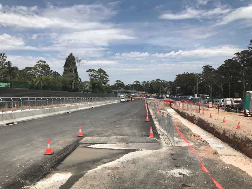
We caught up with Greg Cech from ESO Surveyors, who is currently employed as the Survey Manager on the Northern Beaches Hospital road infrastructure job. Greg has been on that project for two and a half years, and it was going for approximately a year before he started. All of ESO’s work on this project is being done in 12d Model with 12d Field.
As we drove through the project zone, which is just minutes from ESO’s lovely Frenchs Forest office space, we could see their great work in action, and just how much things are taking shape at this point.
Greg confirmed what an exciting project this is to work on, and told us a little about the masses of infrastructure underground – services and such – which of course slowed down the apparent construction for a few months, even though the actual construction was still going on underneath. He said it’s getting to a particularly interesting point from a public perspective as bridges are now being constructed, so people coming past will be able to see the bridges, as well as the slot, which is also starting to be constructed and will be a big visual enhancement in the space. The ‘slot’ is what will come out from Wakehurst Parkway; colloquially it may be known as a ‘tunnel’, but that’s not the technically correct term. Greg told us that it’s actually literally a slot that goes up to about eight metres deep, and the east-west through traffic will run in the slot. Local traffic will run up above it.
During the earlier phases of this project, there were massive disruptions to traffic through the area, but it’s now flowing much better than before. Greg said he hopes it will only get better as they get more and more lanes open up to through traffic.
Warringah Road
All in all, a very exciting project, and one we’re proud to say 12d Model and 12d Field are being used for!
Everyone is talking about BIM, but most people only see bits and pieces of it…a lot of it is jargon, so it’s important to know which parts to pay attention to. Mostly Lee recommends just knowing the basic definitions.
12d Solutions is a member of buildingSMART, which is the international organisation that defines Open BIM or IFCs (Industry Foundation Classes), and a founding member of the Open BIM Alliance (in which, essentially, a number of vendors collaborated, passing IFC data around to see what the problems were), e.g. Qld Govt requires ‘open data’ (no proprietry or undocumented formats) – that’s the future.
12d Solutions is involved in buildingSMART International Conferences/Committees/Expert panels, specifically with the IFC InfraRoom, which is defining the IFCs for:
IFC Model Setup Information Delivery Manual
IFC Alignment
IFC Roads
IFC Rail
IFC Tunnels
IFC Bridges
Lee attends the buildingSMART International IFC Standards Summits, which are held all over the world.
Horizontal vs Vertical BIM
Lee differentiates between these because most people only discuss vertical BIM, which is for buildings…whereas he sees the word ‘building’ in ‘BIM’ as a verb rather than a noun – for linear (horizontal) work.
To date, BIM has been mainly developed for Vertical projects such as building sites and is usually not suitable for large longitudinal infrastructure projects (Horizontal or Civil BIM). In fact, for IFC 2×3, the defined Elements are mainly for buildings. At the moment, it’s necessary to use ifcBuildingElementProxy – a general Element – for Civil work.
What does Civil BIM (Horizontal BIM) Need?
Large coordinates – g. Eastings and Northings
Ability to handle large and long horizontal projects
A Helix for arcs (rather than just a circle)
Strings without diameters and attributes on strings, vertices, and segments
Names for strings (e. string naming convention)
Null Z values
Drainage/Sewer pits and pipes
TINs for surfaces
Trimeshes for 3D objects
Alignments
Linear referencing (for chainage offset)
Transition curves – spirals, cubic parabolas, etc.
A published format that’s Open BIM which everyone can access at no charge, in a text format.
We also need people who can understand all these things (longitude, latitude, heights, coordinate systems, map projections, etc.), and how to bring them together. buildingSMART recognises all this, and hence has set up the IFC Model Setup Information Delivery Manual to explain how to bring together federated models. They also set up a project for looking at roads, rail, bridges, and tunnels – anything where there’s a deficiency in the old BIM processes. The first step in this was a ‘Road Map’ for everything else to be built on top of.
IFC Model Setup IDM – Federated Models
The Solution – a Map Projection and a Height Datum is defined for the entire large site, e.g. MGA 94 and AHD (Australian Height Datum). Lee was heavily involved in writing this. A set of different 2D Helmert parameters is then determined for each small site to go from the local coordinate system (usually in ground units) to the Map Projection. A different Z-shift exists for each small site to go from local height to the Height Datum.
What does IFC Alignment 1.1 have?
An Alignment string with independent Horizontal and Vertical Geometry defined in terms of
Horizontal segments of type
straights, arc
transitions – g. natural clothoid and special rail types
Vertical segments of type:
straights, arcs, parabolas
3D Alignment – a 3D approximation to the Alignment (breaks an alignment up into straight segments)
TINs
Where are we with this process currently?
Large coordinates – IFC files can handle large coordinates; the myth that they can’t is born of architectural packages that can’t handle them, but IFC files themselves have no issues.
The ability to hand large and long horizontal projects – IFC 4.1 Model Setup IDM project has this.
IFC 4.1 Alignment has helices for arcs.
Strings with and without diameters – this is already handled by IFCs, too.
Attributes on strings, vertices, and segments – not yet covered for vertex and segments; use 12da/12dxml.
Name/Code for strings – used in Australia since at least 1980 – already handled by IFCs.
Null Z values in strings – not yet covered; use 12da/12dxml.
Drainage/Sewer pits and pipes – already handled by IFCs.
TINs for surfaces and trimeshes for 3D objects – already handled by IFCs (but not super TINs).
Alignments – already handled by IFCs.
Linear referencing using Alignments – already handled by IFCs.
Transitions – spirals, cubic parabolas, etc. (varying radius helix) – already handled by IFCs.
A published format available free of charge to everyone – already handled by IFCs.
People who understand all of the above plus longitude and latitude, heights, coordinate systems, map projections, and how to bring together disparate data…this part is harder! It’s up to Surveyors and Civil Designers to get involved with this.
Tim Frost from Jacobs and Chris Hunt from Aurecon addressed our 2018 12d Technical Forum delegates about their work on the West Gate Tunnel Project in Melbourne.
Tim has been a Civil Designer for 10 years, and was a Tunnel Zone Civil Designer on this project, in charge of getting all the outputs out as quickly as possible (in his capacity as 12d Design Output Method Developer), and of developing Snippets.
Chris has spent 20 years as a Civil Designer, and on this project was a 12d Lead (as part of this, he developed standards), Tunnel Zone Civil Designer, and Federated Model Developer.
The main focus of their presentation was workflows. They also discussed how they utilised Chains and Snippets in 12d Model in order to produce better quality, more efficient designs, and shared some of what they learnt from the experience.
The Project
The West Gate Freeway is a critical link in Melbourne’s transport network, carrying 200,000 vehicles each day.
The West Gate Tunnel Project is broken up into 3 sections – the West Gate Freeway (out west), the Tunnels (in the middle), and the Port to City (in the east).
The Freeway section involves upgrading from eight lanes to twelve, including an express lane between the M80 Ring Road and the West Gate, and 4 interchange upgrades.
Extra lanes on the freeway between the M80 Ring Road and Williamstown Road
Entry and exit portals where the tunnels connect with the West Gate Freeway
Ventilation structure at the tunnel exit to remove air from inside the outbound tunnel
Interchange upgrades at the M80 Ring Road, Millers Road, Grieve Parade and Williamstown Road
Ramps to Hyde Street to connect trucks directly with local industry
Noise walls to reduce traffic noise for residents and open spaces
Walking and cycling paths to complete missing links in the Federation and Kororoit Creek trails and better connect communities, including new overpasses over Williamstown Road and Stony Creek
Pedestrian bridges replacing the existing overpasses
Freeway Management System to support good traffic flow and safety
New open spaces and planting thousands of trees and other plants in the freeway area.
The Tunnels component includes two three-lane tunnels, one inbound tunnel of 2.5km and one outbound tunnel of 3km – all to take motorists and trucks off residential streets.
The website also lists:
Twin tunnels under Yarraville between the West Gate Freeway and the Maribyrnong River
Entry and exit portals where the tunnels connect with surface roads
Ventilation structures at each tunnel exit to remove air from inside the tunnels
Walking and cycling paths on Hyde Street, Harris Street, Maribyrnong Street and a bridge over Whitehall Street
New landscaped open space in Altona North and Footscray
Freeway Management System to support good traffic flow and safety
Tunnel safety features for smooth operation of the tunnel, including automatic detection for over-height trucks, fire systems and emergency access and exits.
The Port to City section involves a new bridge over the Maribyrnong River River to connect the tunnels, with an elevated roadway along Footscray Road connecting to CityLink, Dynon Road and Footscray Road, running above the centre of Footscray Road, as well as direct links to Port of Melbourne, CityLink and an extension and widening of Wurundjeri Way.
The website also lists:
Ramps to the port at MacKenzie Road and Appleton Dock Road for direct freeway access
Walking and cycling paths for quicker and safer cycling to the city with a new veloway and bridges over Footscray Road and Moonee Ponds Creek
Extending Wurundjeri Way north to Dynon Road to create a city bypass
Freeway Management System to improve traffic flow and safety
New open spaces and planting thousands of trees and other plants in the freeway area.
The Team
The Contractors for the project are CPB and John Holland, and the design work is being one by Aurecon Jacobs JV.
There are many people working on this, in various parts of the globe (South Africa, Philippines, Hong Kong, etc.). Most of the 12d users are from Australian offices.
Design Production – Workflows
12d Model and 12d Synergy are both in use on this project, along with various other packages.
12d Model was selected to do the long sections and cross sections across the entire job, as well as the modelling of the tunnel components and the bridges over the Maribyrnong River.
The team needed to develop efficient processes for bringing in data from other packages. They worked out the best workflows for them, with particular attention to consistency across the entire project.
With their incoming 2D CAD and 3D Models, the main advantage of 12d Model was that they could copy sections of the bridge and tunnel modules and make sure everything was aligned. The process they came up with was running a Chain for each 2D Drawing and each 3D Model that would create a project for each DWG, and then in that Chain they’d also create a date stamp model and use a 12d Synergy search to look for that date stamp model (and compare against a search in another package). From there, they’d work out what was out-of-date and re-run just that Chain.
The team copied DWG files to the 12d Synergy Server and gave them their own Chain, Project, and Mastershare labels – applying a naming convention. Dummy models were created at chain runtime (date analysis). Ongoing date modification analysis was performed using Excel Queries. 12d Synergy was their single source of truth.
Custom Reporting
The team needed a lot of custom reporting due to other software packages being used, with different types of reporting requirements. They learnt to be prepared on the BIM journey for ‘curly’ output requirements, and to ‘make friends with’ Excel and VBA.
They experimented with XSLT Files (12d Report Definition Files), and adapted to Legacy Workflows developed on previous jobs for MX (the hand they were dealt).
The next challenge was how to get data out of 12d Model so it could go into Dynamo and Revit to produce the tunnel rings – for this they enlisted Matt Monk to create a macro to report the perpendicular points between the centre of the tunnel and report it back to the control road which is not in the centre of the tunnel.
Chain Usage
Users were upskilled on how to use parameters in their chains – this happened on the job, with great success.
Custom Widgets were created, with Prompt Result Inputs – (yes, no, cancel). The ‘cancel’ widget was particularly useful in case something fell over halfway through running of the Chain.
Two of their favourite uses were:
Prompt Result Values > PVFs for filename concatenation
Using Widget button to pick result and GoTos they could loop within chains (also very nifty) – naming something differently each time it was used on any number of strings
They employed one Road Design Output PPF per Zone with multiple PVFs, leading to a huge process improvement to the speed of their output, which was noticed by users.
Snippet Usage
Road Barriers – used extensively – need penetration details on stormwater pits; option to change height of first string/extend barrier
Kerbs
Vehicle Clearance and Roll Allowance (AGRD and RTA values) – vehicle clearance was a parameter set by the project (going under bridges etc.) but the sway envelope allowed gathering of AustRoads figures – design speed, left and right crossfall, etc.
L-Shaped Retaining Walls – ability to insert after a string, etc. Means you can set wall thickness, vertical offset to top string, footing RL, footing thickness, leg length forward/back – quite dynamic and went together pretty well
Road Deck Slabs/multi-floor tunnel portals for space proofing – took existing 12d 2-point slab snippet and added ability to put crossfall, RL, etc. Insert a string higher up in MTF and be able to trace it.
Pavement Wearing Course (for XSs)
Sign Legibility (Guide to Traffic Management: Traffic Control Devices) and Sight Line – input speed, sign dimensions, offset to control line, how many words on sign, type of vehicle, number of lanes, etc. -> draws a mesh with sign in distance and ability to profile string
ITS Trenches by Trench Type/make your own (experimental at this stage)
Also experimented with Sub-Soil Drains (how to attach to a pavement layer and such) and Trench
Structure items modelled in 12d Model as space proofing prior to modelling
Tunnel Mesh
Tunnel Portals
Basic Bridge Crossings
2D Road Design Exports
PVFs within Chains used extensively for exporting hundreds of DWGs
Naming Convention Control
Consistency
Repeatability
Quickly expandable
Temporary Entity duplication > String Info Change
Long section/cross section MESH colour control
Label style manipulation
Not good for point count with MESHES though
CAD Team converted DWG to DGN (for their Vic team) for all exports except long sections and cross sections
3D Road Design Exports
General
Road TRIA, MESH and STRS > DWG and IFC > Navisworks
Road TRIA, MESH and STRS > SML > Contractor Setout
12d’s resident Water Resources Engineer, Rob Graham presented a very popular webinar on ARR 2016…
ARR 2016 (Australian Rainfall and Runoff) has updated its hydrology for an ever-changing environment, and 12d Model is ready for the change!
For ARR 2016, the new rainfall intensities and patterns are downloaded into 12d Model from the Australian Bureau of Meteorology (BOM) and the ARR Data Hub. Also for ARR 2016 there are new zones and now ten rainfall patterns for each storm duration instead of the one rainfall pattern used in ARR 1987.