12d Model and Google Earth

I caught up with Rod Burns of Extra Dimension Solutions earlier today to chat about 12d Model and Google Earth, as part of our new 12d Tech Forum 2024 Director’s Cut Webinar Series, which is showcasing some bonus content from our sold-out face-to-face event earlier this year.

This webinar delved into various methods and examples for exporting data from 12d Model to the Google Earth environment. The release of 12d Model 15, along with valuable user feedback, has led to the development of enhanced tools that empower 12d users to effectively present technical civil and surveying data to non-technical audiences.

Rod’s presentation highlighted practical use cases, demonstrating how surveyors, drainage engineers, and civil designers can seamlessly export project data while maintaining comprehensive metadata. This ensures clients can easily explore and gain deeper insights into project elements.

Check out the video of this highly anticipated talk here:

Introducing…the ’12d Tech Forum 2024 Director’s Cut’ Webinar Series

Yesterday, we launched the ‘12d Tech Forum 2024 – Director’s Cut’ webinar series.

The sold-out 12d Tech Forum 2024 was a raging success, and we were thrilled to see so many of you there in person! There was only one problem from our perspective, and that was a pretty good one really – we had more content than we could showcase in three days!

Thus, this webinar series is designed to highlight some of the amazing content we wanted to include in our face-to-face event earlier this year, but which just didn’t quite fit into the programming! Some presentations you’ll see in this series were left out entirely due to overall time constraints (we’ve had requests for an event that runs for longer than three days, but we think it might be just too much for everyone!). Others had to be allocated short time slots because we had too much content – a great problem to have!

[We’ve added more features since July, too, so some talks are being updated for that reason, too!]

In this webinar, 12d Solutions Co-Founder and Managing Director Dr Lee Gregory set the stage for the new series in which we’ll allow some of our presenters the freedom to give their ‘extended edition’ talks…we’ll even include a couple that we couldn’t fit into the Agenda at all!

Here’s a link to the video of the webinar: https://vimeo.com/1018545602/4cda4c6bf0?share=copy

What’s New in 12d Track

Earlier today, I chatted with Jason Knox of 12d WA about ‘What’s New in 12d Track’.

Jason has 17 years of experience leveraging the power of 12d Model. His background in civil design and software development has encompassed the rail, mining, LNG, and renewable energy sectors. Jason’s training initiatives equip individuals and teams with the skills needed to utilise the software effectively.

Jason demonstrates how to generate best-fit geometry from surveyed pickups, visualise offset calculations in plan, section, and custom reports, apply dual-gauge cant on several vehicles while highlighting non-compliant design criteria, and generate stunning 3D trimesh extrusions using 12d’s new Track tools.

If you missed this presentation, the video link is available below!

Elevate Your Land Development Skills with ALDE’s Online Course

We’re excited to announce that enrolments are now open for the ALDE Introduction to Land Development Design course! Developed in collaboration with the Association of Land Development Engineers (ALDE), this Self-Paced Online Training (SPOT) program is tailored for individuals entering, transitioning to, or advancing within the Land Development industry.

In this course, we address a common industry concern: the lack of engineering training tailored specifically to the land development sector. Our goal is to provide additional theoretical and practical knowledge essential for engineers working in land development. We delve deep into the “how” and “why” of our practices, exploring key authorities, stakeholders, standards, and design decision-making processes.

Through a combination of theoretical learning and practical application within 12d Model, we equip participants with the essential tools and insights needed to excel in the field.

Why Choose ALDE’s Course?

1. Comprehensive Understanding: Delve deep into the intricacies of subdivision projects, mastering processes and procedures vital for success, with a particular focus on Victoria’s requirements. The course content is also valuable for those in other states and internationally, providing a strong foundation in land development principles.

2. Cutting-Edge Software Access: Enjoy a full year’s access to the industry-leading 12d Model 15 Software, empowering you to perfect your skills. As a testament to our commitment, 12d Solutions proudly provides software support for the duration of the course.

3. Master the Latest Tools and Features: Stay ahead of the curve with hands-on training on the latest features of 12d Model, ensuring readiness for real-world challenges.

4. Flexible Online Format with SPOT (Self-Paced Online Training): Fit learning into your schedule seamlessly with our flexible online format, accommodating learners of all levels.

5. Continued Access to Resources: Benefit from 12 months of continued access to videos and invaluable content post-completion, enabling you to reinforce concepts at your own pace.

6. Professional Certification:  Receive industry-recognised certification upon completion, bolstering your professional credibility.

7. Engaging Learning Experience: Immerse yourself in interactive quizzes and informative videos, ensuring an enriching learning journey.

8. Practical Exercises: Enhance your skills through meticulously designed practical exercises, reinforcing proficiency in land development design.

What’s Included?

– Discussion of Key Standards: Understand Victoria’s standards, guidelines, and documents crucial for Land Development projects.

– Tailored Training Videos: Access over 100 industry-tailored 12d Model training videos covering Road and Finished Surface Design, and Stormwater Design.

– Insightful Exploration: Gain insights into the “how” and “why” behind Land Development engineering decisions.

– 12d Model 15 Software Licence: Obtain access to the 12d Model Student Software for the course duration. We’re proud to provide software support for one year, ensuring you have the tools you need to succeed.

– Course Certificate: Showcase your achievement with a certificate upon successful completion.

How Many Course Units are There?

This course consists of three units:

1. Introduction to Land Development Guidelines: This unit focuses on theoretical aspects, exploring background documents, regulations, and decision-making frameworks. Tailored exclusively for this course, the ALDE Introduction to Land Development Design document offers an overview of typical Land Development procedures, processes, and requirements, covering areas such as the Land Development Process, Functional Layout Plans, and Water Design.

2. Road and Drainage Design: In this unit, we delve into detailed design using 12d Model to produce the road, pavement, and lot grading. Building on the principles covered in the initial unit, this segment focuses on detailed exploration of road and finished surface design using 12d Model. Course content includes Triangulation, Contouring, and Road Creation methods.

3. Stormwater Design: The final unit covers stormwater management principles and practical implementation using 12d Model. This unit focuses on creating a stormwater design for the road design completed in unit two. Topics covered include Plan Layout, Pipe Sizing, and Flow Analysis.

We have curated industry best practices, with a focus on Melbourne’s key growth areas, to provide comprehensive design standards. While we present various design options and perspectives, it’s essential to adapt these principles to your company’s specific requirements and QA standards. Our approach emphasizes foundational skills, ensuring participants can tackle 70% of design challenges confidently. For more complex scenarios, ongoing collaboration with senior engineers or supervisors is encouraged.

Each unit combines text, images, and instructional videos to facilitate learning. Participants have access to course materials for future reference, allowing for continuous learning and skill development.

We strive to simplify complex concepts, enabling participants to grasp key principles and apply them effectively in their professional endeavours. We look forward to embarking on this learning journey with you.

Significance for Victoria and Beyond

Victoria, with its rapidly evolving urban landscape, presents unique challenges and opportunities in Land Development. This course not only equips you with the skills needed to navigate Victoria’s regulations and standards but also prepares you for similar challenges globally. As an Authorised 12d Model training centre, we’re proud to provide access to cutting-edge software and support, empowering you to excel in your career.

Invest in Your Future Today

Your career in Land Development deserves the best training available. Invest in your future with ALDE’s Introduction to Land Development Design course and take the first step towards a successful career in this dynamic field.

How Can I Enrol?

Enrol today at: https://www.civilandsurveying.com/spot-alde-introduction-to-land-development-design

Introducing…Quick Water Network!

I recently caught up with Dylan Revell of 12d NZ to chat about the Quick Water Network tool in 12d Model 15.

This option allows you to rapidly create a water network layout of 12d Model water strings.

A user-friendly user interface and graphical image overlays make this the easiest way for new or existing users to create a network and understand the relationships and purposes of the nodes and links.

Used as a quick start option for either the Concept Stormwater Designer or Water Network Editor. It makes creating water networks quick and easy!

–Lisa Stewart

12d Model 15’s New GIS interface

I caught up with Charlie Latchford of 12d NZ earlier this week to chat about the new GIS Interface in 12d Model 15.

This new interface enables users to import GIS features from the NZ LINZ data service website (boundary and rasters) and from published GIS REST servers (council Three Waters assets) or in-house GIS systems.

The video of our chat is available from:

–Lisa Stewart

12d GNSS Vector Reporting (GVR)

On Thursday 14th December, I caught up with Sharleen Cole-Swami of 12d NZ to talk about GNSS Vector Reporting (GVR) in 12d Model.

The GVR is a comprehensive tool that enables rapid calculation, graphical display, analysis and reporting for the averaging of GNSS vector observations. Sharleen will provide a detailed demonstration of the module, and show how it can add value to your workflow.

Watch the video of this informative presentation today!


Latest Updates: What’s New in 12d Model 15

I caught up with our Managing Director, Dr Lee Gregory, last week to chat about What’s New in 12d Model 15.

12d Model 15 has been our biggest release to date.

Lee took us through what was in the first release of 12d Model 15, and all the exciting things that have been added since then in our regular sub-versions!

If you missed the live session, the video is a great way to look at what 12d Model 15 can do for you.

The 12d Tech Forum is BACK for 2024

12d Tech Forum 2024

The 12d Tech Forum is BACK for an incredible in-person event!

Get ready for an unforgettable experience in sunny Brisbane! After six long years, the 12d Tech Forum will return to BCEC in 2024.

The 12d Tech Forum 2024 offers a fantastic opportunity for engaging in educational sessions, fostering valuable connections, and networking (sometimes over dinner and drinks!) with other members of the 12d community.

The 12d Tech Forum provides education and inspiration to infrastructure professionals. It is the top destination for 12d Model and 12d Synergy customers and partners to gain knowledge and become a part of a thriving community of industry leaders and enthusiasts. The 12d Tech Forum is where the infrastructure’s finest minds come to learn and share, and it aims to fuel creativity, offer practical expertise, and facilitate connections that drive an inclusive future.

Join us and the 12d Tech Forum community for this unmissable three-day event; see https://12dtechforum.com/ for more details and to register.

When and where will the 12d Tech Forum 2024 take place?

Dates: Sunday 28th, Monday 29th, and Tuesday 30th July 2024

Venue: Brisbane Convention and Exhibition Centre (BCEC) – Boulevard Level

How much will it cost?

The Full Tech Forum Package for $1,220 +GST (currently discounted to $1,120) includes:

  • Welcome Event for one person
  • Tech Forum Gala Dinner* for one person
  • 3 Full Days of Tech Forum Main Sessions
  • Any ‘Birds of a Feather’ Sessions
  • Award-winning food at all Morning/Afternoon Tea Breaks and Lunches
  • 12d Polo Shirt and Other Goodies!

*Includes 12d International Innovation Awards 2024 Ceremony

Day passes will be released in due course. Credit card payments are accepted through our online store – keep an eye on www.12dtechforum.com for more details as they become available.

We’ve also secured group rates at nearby accommodation, through OzAccom (as per our previous Brisbane events) – book through https://events.ozaccom.com.au/12d-technical-forum-2024/accommodation to secure this deal!

What to expect from the 12d Tech Forum 2024

At this three-day event, 12d Solutions will be highlighting exciting features in 12d Model including new sub-versions, as well as new developments in 12d Synergy, and more! We will continue the ever-popular ‘Birds of a Feather’ breakout sessions on Design, Surveying, 12d Water, and 12d Synergy.

This event will be an invaluable learning and networking experience for users of 12d products and other industry professionals, in all areas of civil design, surveying and construction, water engineering, data management, and project collaboration.

The 12d International Innovation Awards will be presented at the Tech Forum Gala Dinner – contact techforum@12d.com for more details on entering.

The 12d Tech Forum offers:

  • A great opportunity to increase your 12d Model/12d Synergy skills
  • The ability to interact with the developers of 12d products
  • The chance to network with, and learn from, other 12d users.

Reasons to attend the 12d Tech Forum 2024

#1 Gain Invaluable Education and Training

Whether you’re a tech newbie or a super user, the 12d Tech Forum is the perfect place to equip your team with invaluable tips and tricks that will boost efficiency and productivity. Discover the latest software updates, industry trends, and best practices to help your team stay ahead of the curve.

With a jam-packed 3-day schedule, you’ll have plenty of opportunities to immerse yourself in the latest tech innovations and learn from industry experts who will share their insights on how to use these innovations to your advantage.

#2 Expand Your Network

The 12d Tech Forum isn’t just about education and training – it’s also a fantastic opportunity to connect with other professionals in your field. Rub shoulders with like-minded individuals, make valuable connections, and exchange ideas that could take your career or business to the next level.

Our event attracts a diverse range of infrastructure professionals, from industry leaders to up-and-comers, giving you the chance to meet people from all walks of life and learn from their unique experiences. By joining the 12d Tech Forum you’ll open yourself up to new opportunities, partnerships, and collaborations that could shape your career trajectory for years to come.

#3 Get Inspired by Industry Leaders

Elevate your knowledge and gain valuable insights from the 12d Model and 12d Synergy leaders themselves. Learn about the latest technological trends and advancements that will shape the future of the industry. Discover innovative solutions and strategies to help you take your business to the next level. With a diverse array of guest speakers and industry leaders, you’ll be inspired to make a difference in the infrastructure world and beyond. Leave the 12d Tech Forum feeling motivated, informed, and ready to tackle the challenges ahead.

#4 Unleash Your Potential

The 12d Tech Forum offers a unique opportunity for personal and professional growth, with access to the latest industry trends, practices, and innovations. Expand your knowledge and network with like-minded individuals who share your passion for technology. Immerse yourself in a collaborative environment where you can exchange ideas and gain valuable insights. Unleash your potential and discover new horizons for your career.

#5 Join the 12d Community and Thrive Together

The 12d Tech Forum is more than just an event, it’s a chance to join a thriving community. Connect with the 12d Model and 12d Synergy teams, including executives, to share your knowledge and gain valuable insights from experts in the field. Make lifelong friends and be a part of a community that has been growing and thriving for over 30 years. Together, we can innovate, inspire, and improve the industry. Join us and become a part of something bigger.

#6 Celebrate the Industry’s Achievements and Have Fun!

Our Innovation Awards Ceremony is a highlight of the event. Attend the Tech Forum Gala Dinner to applaud the ground-breaking work and extraordinary achievements of the global 12d Community. Be inspired by industry leaders and visionaries and enjoy an unforgettable experience filled with industry and media exposure, prizes, food, and drinks. Don’t miss your chance to become a 12d visionary and celebrate the industry’s success with us. And if you enter the Awards yourself, you might even be one of those receiving accolades on the night!

Need to convince your boss you should be attending the 12d Tech Forum?

Download our Proposal Letter to show how the 12d Tech Forum boosts your growth and benefits your company.

Click here to download the letter, update it as needed, and send it on to your boss today!

Registrations are already rolling in; let’s get excited together! Register today through www.12dtechforum.com.

An Initial Guide to ISO 19650

Brief Overview of ISO 19650

Scratching your head about ISO 19650? Don’t worry, you’re not alone!

You’ve probably heard ‘ISO 19650’ dropped into discussions around BIM and digital engineering. Likely this was quickly followed by a wave of foreign terminology: PIRs, AIRs, BEP, CDEs, appointing party, information containers, the list goes on…

This article aims to introduce you to the ISO 19650 series and provide an overview into the key concepts and principles defined. We’ll discuss why the standards are important, summarise the information management process, and work through the CDE workflow for the delivery phase of assets.

ISO 19650 is becoming the global BIM standard for information management and many Australian & New Zealand organisations are working towards certification with the standard. So whether you’re a consultant, contractor, operator, asset owner, or client, strap in – you’ll need to understand ISO 19650.

For a comprehensive overview of ISO 19650, read The Ultimate Guide to ISO 19650 by 12d Synergy here.

What is ISO 19650?

ISO 19650 is a series of international standards which define a common unified framework for the effective collaborative production and management of information across the full lifecycle of a built asset using Building Information Modelling (BIM).

Essentially the overall objective of the series is to ensure that the right people are working on the right information at the right time. With the ultimate aim being to help deliver built assets on time, within budget, and to standard.

ISO 19650 is concerned with information management in the delivery and operational phases of assets and exists within the larger context of your organisation’s asset management and QA systems.

The Importance of ISO 19650

As previously mentioned, this standard is designed to help you, whether you’re the client, asset owner, or part of the team working on the project. Not only does this standard remove wasteful activities which can create information that is inaccurate, ambiguous, or incomplete, it’s intended to ensure collaborative work and effective communication among the different parties is accomplished. This means clear channels of communication not just with the different disciplines and teams needed for a project, but also between the client and the consultancy or contractor.

Basic Principles of ISO 19650

Created and set by the International Organisation of Standardisation (ISO), there are several basic principles which govern the standards:

  1. The client establishes the project’s information framework, which includes the information requirements, the standards utilised, delivery milestones, the information production methods & procedures, the Common Data Environment (CDE), and the Project Information Protocol. This is then communicated to prospective delivery teams.
  2. The delivery team(s) plans a schedule to meet the Project Information Protocol, and mobilises resources (people, technology, processes) to achieve this. Processes and systems are tested, and further team members are hired and/or trained to ensure their suitability.
  3. Information is collaboratively produced and managed between task teams (i.e., across disciplines).
  4. Information is managed in a CDE, a collaborative and secure platform. This system ensures the right people work on the right information at the right time.
  5. At each level, information that is produced by the task teams are assessed and reviewed for approval. Access to information is given and shared accordingly to the correct and appropriate teams.
  6. Once everything has been given the final approval by the client, the information is aggregated together and archived for the ongoing operation and maintenance of the asset. If future data is needed on the asset, this Asset Information Model (AIM) can be referred to.

The Information Management Process

ISO 19650-2 defines a structured process for the delivery of built assets known as the information management process. This process has 8 stages starting from the initial assessment and concluding on project completion as seen in the following image:

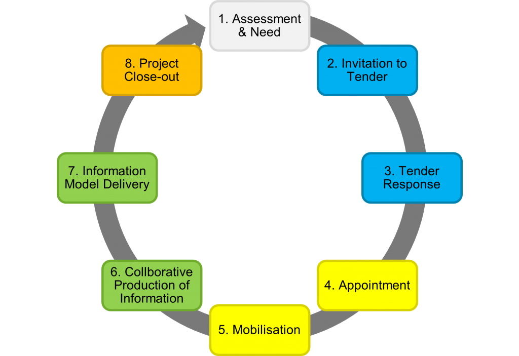
It’s important to note, some stages may be repeated for each appointment (contract) of the project and the lifecycle is not a simple linear relationship. For projects with multiple appointments (i.e., different lead appointed parties for design and construction) stages 2 to 7 are repeated. Whilst stages 1 & 8 occur only once per project.

There are three phases within the information management process. The procurement phase (2-3), the planning phase (4-5), and the production phase (6-7). You’re probably already familiar with the project delivery and asset lifecycle. But ISO 19650 introduces new terminology to globalise the standard.

These 8 stages are summarised below. For a comprehensive overview of ISO 19650, read The Ultimate Guide to ISO 19650 by 12d Synergy here.

1) Assessment & Need

The appointing party (E.g., the client) determines why works are to be carried out, an example for this could be to improve a highway’s capacity. They will also need to establish the project’s information requirements, information standard, and project milestones which are compiled into the PIP.

2) Invitation to Tender

The appointing party then establishes their tender response evaluation criteria, so how all bids will be assessed and judged. Once the evaluation criteria are finalised, they will issue a tender inviting organisations to formally bid for the works.

3) Tender Response

Prospective delivery teams (E.g., engineering consultants or contractors) prepare and submit a response showcasing and demonstrating their approach to the works. The response should also assess their capability and capacity for the job. This is outlined in their pre-appointment BIM Execution Plan (BEP) and Risk Register.

4) Appointment

Tenders are evaluated and the successful delivery team is selected, known as the lead appointed party. The team now undergoes detailed planning and prepares a schedule outlining how and when items will be completed to meet the appointing party’s Exchange Information Requirements (EIR) and information delivery milestones.

5) Mobilisation

The lead appointed party ensures they have the right people, processes, and technologies in place to deliver the works. Teams are trained up if needed and the Information Production Methods and Procedures are tested and documented to ensure they are appropriate for the works.

6) Collaborative Production of Information

Works begins and information is generated, coordinated, checked, reviewed, and approved by the lead appointed party.  Each appointed party (task team) within the delivery team may represent a different discipline on the project (E.g., road design, geotechnical, electrical) and once their information has been approved, they can share to other teams for reference and coordination.

7) Information Model Delivery

The appointing party reviews the information model against their acceptance criteria and either approve or reject it as a contractual deliverable. This is repeated for each milestone and information delivery on the project until the appointment is completed.

8) Project Close-out & Asset Information Model Aggregation

Once all appointments have been completed, the information is archived and aggregated into the AIM for the ongoing operation and maintenance of the asset.

Information Generation, Coordination, and Federation

The production phase or steps 6 & 7 in the information management process are crucial in terms of maximising resources and eliminating those wasteful tasks mentioned previously. This is where a CDE comes into play.

It’s the technology that enables the ISO 19650 information process. A collaborative platform which once information containers (i.e., files, data, design, models) are produced, it can be managed and shared within this system.

The onus is placed on the appointing party to implement and manage a CDE on the whole project, however it’s unlikely that there is only one CDE which manages everything in the project. Each lead appointed party may be responsible for managing their own CDEs for their appointed parties. The CDE is likely to be an ecosystem of integrated IT system rather than a singular product.

CDEs can include data management systems (like 12d Synergy), geospatial information systems, and engineering management systems.

ISO 19650 states that information within a CDE should be:

  1. Created once and re-used many times, eliminating any future rework and wasteful tasks. There will be newer versions of information that will constantly be updated until approved.
  2. Continuously shared and trusted amongst team members. Approved information can be used as reference by other teams.
  3. Have a clear auditable history, identifying where the information came from, who amended it, and when this was done.
  4. Checked, reviewed, and approved before it is shared with other team members. The information should be authorised at each level. This must occur within task teams, before the delivery team, and finally with the client.
  5. The state of the file within the CDE workflow needs to be clearly identifiable, along with its revision and status. Access should be controlled accordingly depending on who the team member is.

The CDE workflow organises the flow and management of information across the whole lifecycle of an asset across four states: Work in Progress (WIP), Shared, Published, and Archived. The process can be seen in the image below:

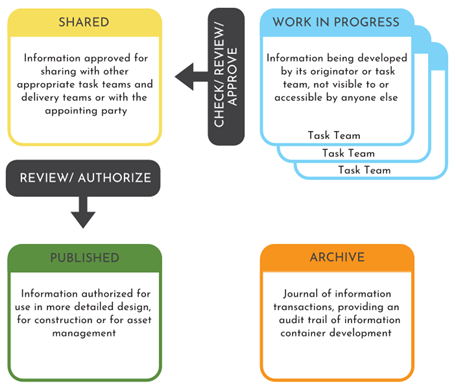
Work in Progress (WIP) (Creating Information)

This stage is where information production occurs by task teams. Files are editable and are unapproved for sharing with the wider delivery team. Access is controlled by the CDE to prevent other task teams from working on, referencing, or issuing draft information.

WIP to Shared (Information Coordination)

WIP information is shared with other task teams after passing a QA check and technical review. Shared information is not approved as a deliverable but approved to be shared with other members of the delivery team.

Shared (Coordinated Information)

Shared information is information that has been verified to be shared with the delivery team. Shared information is read-only and must be the most current approved revision of the information container.

Shared to Published (Information Delivery)

The information is then approved internally for publishing with the client. Publishing occurs for each information delivery milestone.

Published (Information Deliverable)

Published information is information that has been reviewed and authorised as a deliverable by the client. It is read-only information and must be the most current authorised revision of the information container. Published information is accessible by the entire project team.

Archived

Once all delivery milestones have been met and all appointments have been completed, the information model is aggregated and archived to enable the ongoing operation and maintenance of the asset. This ensures there’s a definitive final version of project information available in case it needs to be referred to by the client, after the project has been completed. This is read-only information and only visible to the client and the CDE administrator.


Now, this is an extremely brief overview. There are more key concepts, principles, and processes of the standard. To learn more about ISO 19650 and all its details, check out 12d Synergy’s comprehensive overview of the series: The Ultimate Guide to ISO 19650 by 12d Synergy.