Working Remotely to Deliver Land Development Projects: What Do You Need to Know?

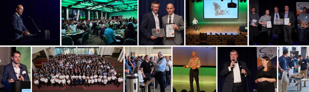
The 12d Tech Forum 2021 involved a veritable cornucopia of incredible presentations, showcasing what 12d products can do.

One of these amazing talks was delivered by Grant Wandel, a Surveyor and Civil Designer with Southern Land Development Consultants in New Zealand. Working on a broad range of infrastructure and development projects globally, Grant is responsible for leading the design of civil infrastructure for Southern Land in Wanaka, New Zealand. Grant has used 12d Model throughout his career, and in recent years has been using 12d Synergy as well.

Watch the recording

Southern Land is a team of land development and subdivision consultants with offices in Auckland, Wanaka, and Queenstown. Grant demonstrated how such teams can work from anywhere in the world to deliver land development projects from end-to-end using 12d software.

The Project

Aerial photo – Clearview Wanaka

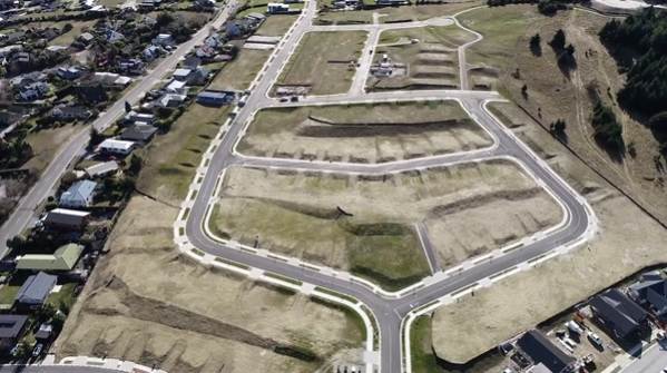
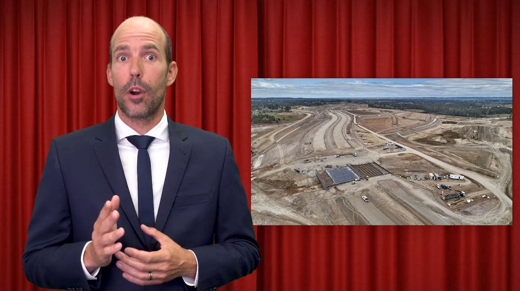
Clearview Wanaka involved 119 residential lots and around 40,000 cubes of earthworks. The team had to do ‘a bit of everything’ on this job – drainage, sewer, stormwater, service reticulation, earthworks, tricky site management controls, etc.

Southern Land was responsible for:

  • Lot Layout/Scheme Plan Design
  • Civil Design Package
  • Contract Administration
  • Environmental Management
  • Construction Observation
  • Set-out/as-built survey
  • Land transfer survey.

They used 12d software for the complete project:

  • 12d Synergy – project creation
  • 12d Model – from concept through to completion12d Synergy – project delivery.

Working Remotely

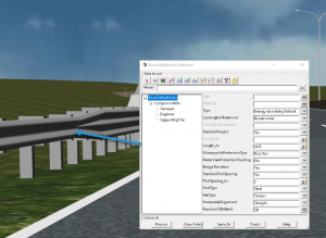
The 12d Synergy Sync Tool was used to manage all 12d Customisations throughout their offices by pushing out all nodes files, User Library files, feature code libraries, updates, etc. to any of their 12d users’ C Drives, from anywhere in the world.

Working remotely became especially important to Grant during this project. He actually did most of the earthworks and civil design from an apartment in Slovakia! This incredible freedom to be able to travel, when necessary, but be able to continue working, was a real game-changer. And once the pandemic hit, needing to work from home became vital for their other staff as well. The flexibility offered by this has revolutionised the way they work.

Automation All the Way

Southern Land has been developing their 12d Synergy workflows over the past few years. Their data gets pushed into 12d Synergy as Attributes, which are used all the way down to plotting and drafting, as well as for reporting. Their documents and templates come out of 12d Synergy automatically saving an incredible amount of time. This project had up to 80,000 file changes and so certainly needed to be properly tracked! 12d Synergy also proved to be invaluable for sharing out 12d Model projects.

12d Model’s dynamic design capabilities have been vital to Southern Land on this project. Grant spoke of 12d Model helping them to be adaptable to the changes that inevitably happen throughout a project, and because they’ve been able to automate so many of their systems, not let drafting time impact this.

12d ‘From Go to Whoa’

Southern Land produced the full civil design for the project with 12d Model, including scheme plans, road and earthworks design, drainage, dynamic stormwater modelling, and multi-page plots.

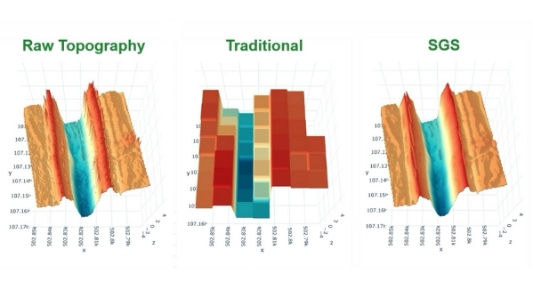
Using 12d Model, Southern Land created superTINs from topographic surveys (from a variety of sources), UAV Imagery, and LiDAR Point Cloud Data from their local Authority.

The team utilised many other tools within 12d Model for design and surveying including the 3D Viewer, lot labelling in Estate Lots, CAD Tables (very handy to be able to update something within a CSV file and then recalc that CSV file in a table on the plan face), and Chains to automate drafting as much as possible.

Earthworks and Roads

Earthworks from the project

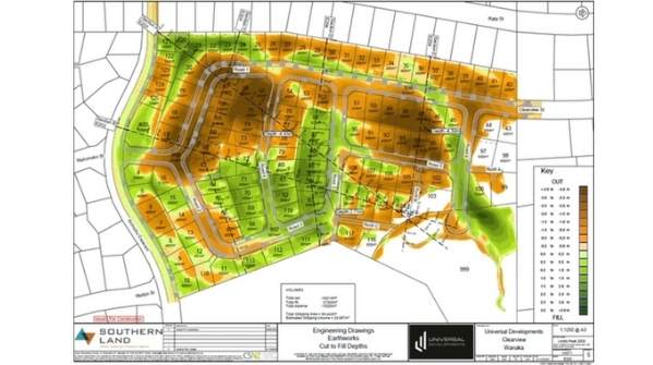
Southern Land’s use of 12d Model’s Alignment Computators meant their alignments were ‘talking to each other’ – that is, if they adjusted one alignment, the elevations would all change around. This was another huge time-saver for them.

Grant has three MTF/Snippets that he’s customised from what comes ‘out of the box’ with a few edits for their local Authority to help them build a road design very quickly.

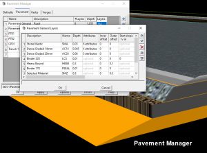
The Pavement Manager tool in 12d Model also proved very useful. It creates trimeshes so Visualisation works automatically, and the trimeshes used to run quantities for scheduling.

Chains were employed again, for roading and earthworks design, and generating plots. This continued automation of drafting meant that Grant could apply Attributes within Snippets to automate the drafting of any changes he made (change of kerb type, automatic label, label map file, labels at kerb type, etc.).

Once all these systems were up and running, when a change was made, not much else had to be done except run the Chains. This saved a great deal of time.
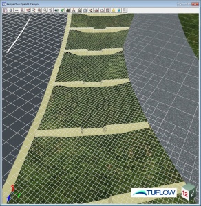
Visualisation

The view over Lake Wanaka

With the Trimeshes (straight out of Pavement Manager), Southern Land could perform all their drainage modelling through the Drainage Network Editor, with no extra effort required to get their Building Platform Visualisation up and running and have things looking great.

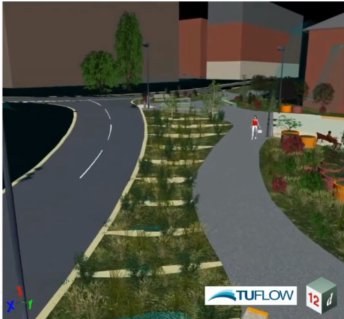
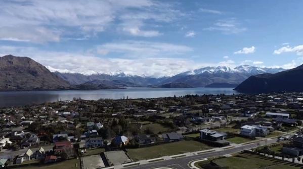
The view on this project was amazing, and the team needed to show prospective purchasers what aspect they were going to get from their lots. By exporting KML to Google Earth,   prospects could pan around in Google Earth and easily see views from their lots. Most of it was automated so Southern Land didn’t have to spend a lot of time to get something that looks fantastic.

Clash Detection and Augmented Reality were also useful – Southern Land tested this with roading Trimeshes and drainage networks and were able to see clashes underground before putting the pipes in the ground.

Drainage

12d Model’s Drainage tools are incredibly powerful. The Southern Land team first used the Rational Method for all their pipe sizing, and on this project, there was a centralised stormwater attenuation system and Dynamic Analysis was run against this.

Grant said it was great to have all these features in one software package – they could do all their drafting, update a road or surface and rerun dynamic calculations  to compute invert level changes, tweak orifices and weir elevations, check heights needed for an overflow, and much more. Being able to tweak the model without using any other software really sped up the process in this stage of detailed design.

The team also used 2D Roadflow to do overland flood analysis and automated calculations and graphs for reporting, and again relied heavily upon 12d Model’s capabilities for automated drafting, at the click of a button, to assist with their drainage design.

Multi-Page Plots

So how did they bring all this together onto a plan face? What the contractor and the Council were going to see was all dependent on plotting. The answer was 12d Model’s Multi-Page Plots.

The team found View Favourites particularly useful when it came to plotting. In addition, they again utilised 12d Model’s automated drafting tools for dynamic dimensioning, dynamic leaders, string attribute labels, etc. They also found the Drawing Register vital for keeping track of where revisions were in the project.

For this project they had 57 sheets in their final “Issue For Construction” set, so the ability of 12d Model’s Multi-Page Plots to plot by chapter or even individual page, instead of having to go through the whole sheet, was another massive time-saver. ‘Combine PDF Files’ was invaluable for updating single sheets in an existing set.

Construction Preparation, Machine Control and QA

Quantity calculations were  automated  as well as scheduling. 12d Model also produced all Southern Land’s Machine Control Files and survey setout data.

A great deal of Quality Assurance (QA) had to be performed throughout the project, and 12d Model assisted with this. For their MDM compaction tests, they were able to convert to CSV in 12d Synergy, then read this straight into 12d Model through Attributes.

As-Built Data

Their local Authority no longer takes AutoCAD files but instead uses GIS data or 12dXML. The team used 12d Model’s Attribute Manipulator to convert the as-built survey data into the attribute format required by the Authority and then wrote out an 12dXML file.

They were able to do a lot of the Attribute mapping from their already QA’d data they had checked throughout the project. Not having to recreate this data in any way saved  a lot of time.

Land Transfer Survey

Southern Land does all their land transfer surveys from 12d Model. Their Land Transfer Data Preparation is all produced in 12d Model’s Traverse Spreadsheets and uploaded to LINZ. Being able to do all the prep in 12d Model was particularly useful for checking the cadastral surveyor’s precalcs in advance, and shared models were used across the design project to see where pegs will land, in order to work out any potential clashes during construction.

Document Control and Remote Data Access

How do you deliver this volume of data to the right people? How do you keep track of it? For Southern Land, the answer to this question was simple…12d Synergy.

For project delivery, the Issue Files functionality was very useful as it’s great for large document transfers, and automatically keeps track of document control through Document Transmittals. Grant said issuing file sets really helped the process when they had multiple projects running and were trying to remember which data had gone out. It became so easy to check.

Using 12d Synergy templates with pre-populated attributes and having a single point of entry drastically reduced administration time, especially in the cases of inspection reports and completion certificates. All the data came out of the Attributes from within 12d Synergy.

The Takeaway

As a civil designer for this project, Grant was incredibly happy with the way 12d Synergy and 12d Model worked seamlessly together – the team could automate everything, make it adaptable, and limit the time spent drafting.

This project was mostly completed during a six-week lockdown and an eight-week trip to Europe. Being able to work from anywhere created flexibility that would have been beyond imagination just a few years ago.

To learn more about working remotely with 12d products, and much more, register for the On-Demand 12d Tech Forum 2021 at https://12dtechforum.com/.

Traverse Spreadsheets: What’s New in 12d Model 15

I caught up with Sharleen Cole-Swami of 12d NZ this week to chat about the updates made to Traverse Spreadsheets in 12d Model 15.

There are updates that have been added to make people’s lives easier, and updates that have been added in response to some new Cadastral Surveyor Rules implemented in 2021.

In this informative session, Sharleen provided a brief introduction to the 12d Model 15 interface, and to Object Tree, then delved into all things Traverse Spreadsheets. This included such updates as the Bearing Correction and Show Description tick boxes, plus additions to the Data, Observations, Points, and Parcels tabs of the Traverse Spreadsheet Parameters panel (mostly due to the addition of Object Tree into 12d Model).

This session will be of particular interest to Surveyors in New Zealand, so we encourage you in particular to watch this video.

ARVE error: Invalid datetime: Traverse Spreadsheets: What's New in 12d Model 15

–Lisa Stewart

Up Your Hydraulics Game with 12d Model + TUFLOW’s Sub-Grid Sampling and Quadtree

Bill Syme (TUFLOW Software Lead at BMT) and Rob Graham (Water Resources Engineer at 12d Solutions) presented a fantastic talk at our recent 12d Tech Forum 2021, detailing exciting new features in TUFLOW software, and their integration into 12d Model:

TUFLOW’s implementation of Sub-Grid Sampling (SGS) and Quadtree grid refinement produces quality results without the need for a small cell size throughout the entire TUFLOW grid. 12d Model 15’s integration with TUFLOW includes both features.

Both Sub-Grid Sampling and Quadtree Meshes have really allowed TUFLOW to improve how they model not only urban areas but also rural catchments – it’s been a real game-changer for hydraulic modelling of surface flow.

In his presentation, Bill also touched on advances in non-Newtonian dam break studies, and on TUFLOW’s work with Modelling Bridge Decks, a joint research exercise with the Department of Transport and Main Roads, Qld (TMR).

In a recent LinkedIn article, Duncan Kitts (UK/Europe Software Lead at TUFLOW) wrote about the 2020-01 release of TUFLOW and its host of exciting and ground-breaking functionality including SGS and Quadtree Mesh. We’ll include some of Duncan’s thoughts on this page, too.

What is Sub-Grid Sampling?

Image: Sample elevations at fine resolution across whole cell
Image: Sample elevations at fine resolution across whole cell Source: https://megamanual.geosyntec.com/npsmanual/waterqualityswales.aspx

These days, both aerial and terrestrial LiDAR data are available in increasingly high resolution, but the vast majority of the information is not commonly used in hydraulic modelling.

2D hydraulic modelling software such as TUFLOW will traditionally sample the underlying digital terrain model (DTM) by taking the elevation measurement at the centre of the cell (as well as cell face midpoints in TUFLOW’s case), or by taking an average/minimum of the underlying DTM elevations as the cell elevation. 2D hydraulic model grid cell sizes are usually 2-10 times the size of available DTM cell sizes, so the sub-grid scale topography that may be present in the DTM is not utilised within the 2D hydraulic model.

Improved representation of detail within open channels is one of the reasons that one might choose to represent open channels using 1D hydraulic modelling, or use flexible meshes, both of which are significantly more time-consuming to set up correctly compared to a regular fixed grid.

With SGS, rather than using a single elevation value for the grid cell elevation, underlying DTM cell elevations can be used to determine a water surface elevation vs volume relationship for each grid cell. A similar action is performed along the cell faces, resulting in the full array of information in the DTM still being utilised within the 2D hydraulic modelling despite the hydraulic model grid resolution. This improves the representation of the underlying topography and the accuracy of simulated results.

Traditional Approach vs SGS Approach


Traditionally, surface area would be broken up into cells, and the elevation data associated with a cell would be extrapolated through sampling a single elevation from the centre to create a square tub that holds water. From there, to see how the water moves around from one cell to the next, a single elevation in the middle of the cell side would be sampled, and a flat rectangular section used.

Often this coarse representation of the underlying Digital Elevation Model (DEM) or Triangulated Irregular Network (TIN) would miss out key features.

With the SGS approach, however, sample elevations can be taken at fine resolution across each cell – across the whole cell. Instead of a single point, a relationship or curve can then be generated. This is effectively the cell volume with height, and the flow area for each cell side. This method provides a far better representation of what’s inside the cell – i.e. a much closer representation of the DEM or TIN.

Benefits of Sub-Grid Sampling

SGS improves flow depth estimation accuracy at stormwater pipe network inlets, and increases the accuracy of flows entering stormwater pipe networks.

The previous way of dealing with the issue of coarse resolution – using very small cell sizes – caused very long run times and large output files.

With SGS, we get:

  • Consistent results for different cell sizes, meaning we can use larger cell sizes, giving faster run times
  • Consistent results for different orientations (i.e. you no longer have to align the grid/mesh with the gutter)
  • No need for gully lines (can now be detrimental)
  • More accurate inlet flow capture

Elimination of numerical loss effects associated with oblique, coarsely represented steep-sided channels leads to improved above-ground result accuracy.

More accurate representation of above-ground topography means faster stimulation as models can be built using larger cell sizes.

We also see improved flow depth estimation accuracy at 1D inlets, which leads to more accurate storm water network results.

In addition, by using the underlying sub-grid scale topography, it is possible to more accurately represent the potential storage and conveyance within the system being modelled.

The use of sub-grid sampling can also assist with model calibration and is particularly useful for whole of catchment direct rainfall models.

The amazing benefit to modellers and workflow efficiency is that the modeller can calibrate a model and the calibration can still be valid when grid resolution is changed.

What is Quadtree Mesh Refinement?

The Quadtree grid shown here for the Water Sensitive Urban Design (WSUD) device refines in two simple steps - from the road/path straight to the detailed grid in the WSUD device.
The Quadtree grid shown here for the Water Sensitive Urban Design (WSUD) device refines in two simple steps – from the road/path straight to the detailed grid in the WSUD device.

Quadtree is the simple concept of splitting one 2D cell into four, over and over again – allowing your 2D model to have variable cell sizes based on subdivision of your square cells, down and down. With Quadtree, you can refine your model resolution whenever and wherever you want, to achieve improved accuracy.

Quadtree is very easy to set up – this can be done either by using existing polygons like a road layer or by drawing polygons to define nesting and giving each polygon a level or resolution. Currently Quadtree can accommodate up to 9 levels to nest down into, one level at a time (more than enough for everyone who’s used it so far). If you want to skip one or more levels, Quadtree even automatically transitions.

With the inbuilt automated level approach, you can simply skip to the desired level and TUFLOW will auto-buffer one cell for each skipped level.

The advantages of Quadtree are, among others, that it allows you to get refined results where needed, it’s very easy to set up, and it provides faster simulations due to fewer 2D cells (run times typically decrease by 2 to 5 times). Quadtree also enables refined representation of topography features and hydraulics where the user desires.

So far, no disadvantages have been found unless run-times increase because your non-Quadtree model is at a different resolution.

SGS + Quadtree Combination

In the urban world, the capturing of inlet flows is far more accurate, plus we achieve higher resolution modelling (in terms of flow patterns) with these two combined. This means we can be much more realistic with our modelling. It’s a real game-changer.

With sub-grid sampling, despite using larger grid cell sizes, the underlying topography is still used. Results using coarser grid cell sizes and SGS are comparable to those using a much finer grid cell resolution at a fraction of the computational effort, and data storage.

Used in conjunction with TUFLOW’s Quadtree solver to allow the user to focus detail where required without compromising computational efficiency in locations of little topographic variability, SGS can be used to ensure areas of coarser grid cell resolution, still providing the necessary detail for robust 2D hydraulic outputs.

SGS and Quadtree into 12d Model

How does 12d Model implement SGS and Quadtree? Boundary Polygons wrap a polygon around a set of strings in a view.

Then in RoadFlow, we enter the TUFLOW road extent and set the SGS frequency, plus specify the Quadtree model. Roadflow also handles AR&R storms.

Non-Newtonian Dam Break

With non-Newtonian flow, fluid no longer behaves like water – viscous characteristics change as forces are applied. For example, tailings can liquify when subject to gravitational forces from a dam failure, and paint becomes thinner as you force it with a brush.

These events can now be simulated in TUFLOW. AS always, results may be animated using 12d Model Visualisation via Timelines.

Modelling Bridge Decks

This has always been somewhat problematic.

TUFLOW, together with TMR Queensland, set out to find a way to improve bridge deck representation in flood models to reduce uncertainty of hydraulic model results, leading to better bridge designs.

To do this TMR have been doing a range of modelling – CFD (incredibly high resolution) and TUFLOW, as well as other benchmarking and comparison testing using measured data.

Conclusion

SGS and Quadtree combined have become a real game-changer for urban modelling. This approach is allowing users to really drill into detail to model roadways, round-abouts, channels, SUDS and WSUD features, in detail and with fine resolution.

Inlet flow capture is much improved, and in terms of modelling roads and gutters, it really does help enormously as well.

References:


12da Library – Working Smarter

I caught up with Dylan Revell of 12d NZ to talk about working smarter with the 12da Library.

The 12da Library is an option in 12d Model software that can be used in many different ways. Whether it is used as a quick way to import and place complex 12d Model items such as water models or 3d objects, or simply as a quick creation library for drafting and plotting options like standard details, typical sections and more, this webinar will cover some of the ways that the 12da Library can help you work smarter.


Items covered included setting up and using the 12da library to import and edit 12d objects, adding details to cross section plots, and of course using the library in conjunction with MPS plotting.

–Lisa Stewart

Results of the 12d Innovation Awards 2021

For our recent 12d Innovation Awards, the judges were overwhelmed, as in previous years, by the quantity and quality of the entries, and found it exceptionally difficult to decide on the winners.

The 12d International Innovation Awards celebrates the ground-breaking work and extraordinary achievements of the global 12d Community. From clever macros to awe-inspiring projects, our users find ingenious solutions to challenging issues, and push the possibilities of technology, surveying, engineering, and construction.

The 2021 Awards involved categories for: Design, 12d Synergy, Surveying & Construction, BIM & Visualisation, ‘Banishing the Drafting Demon’ (which recognises companies that can automate their plotting and drafting processes, straight from the 3D model), Customisation, and 12d Water (which includes Drainage, Sewer, Utilities, & Rivers). We also awarded a prize for the Overall Winner, and Highly Commended prizes for Small, Medium, Large, and Government categories. Congratulations to David Healy of Orion Consulting, Hamish McRae of Lynton Surveys, Kelly Yi and Richard Traill of WSP, Seb Woodland of GHD, and Reza Zolfagharzadeh of Brisbane City Council for your Highly Commended entries!

The winner of the Design category was Peter Zimmerle of Harrison Infrastructure Group.

Peter developed a tool that takes the results produced by OS Roads to generate MTF files.

OS Road is a design tool provided by TMR Queensland which determines the Operating Speed of a proposed road. It’s a great tool, but the results are not linked to the model or drawings, and there isn’t a convenient way to display or visualise the results. The MTF files generated by Peter’s tool are used to create strings to check OS Road results.

Peter uses attributes on the OS Result strings and attribute mapping files for plan and paired cuts in long sections, to make the results of the OS Road easily and quickly accessible to the designer. This slashes the time taken to assess design options.

The winner of our 12d Synergy Award for 2021 was the team from Premise, Andrew Langdon and Glenn Brosnan.

Premise developed a full CAD workflow inside 12d Synergy. CAD templates, block attributes, xrefs, and plotting are all handled in 12d Synergy. Drawings are collaborated across 11 Aussie offices and in Vietnam.

  • PDF transmittals are created using 12d Synergy Attributes and issued using Issue File Sets.
  • Premise has also leveraged a Hybrid cloud set up with a cloud server and local FRS
    Premise has reported a $240k annual saving as the result of improved collaboration and minimised FIFO.

The winner of the Surveying & Construction category was a joint effort – Sam Cech of Tatras Consulting and Mark Finlayson of Envivo.

Sam and Mark came up with a workflow and custom macros to turn as-built survey of underground utilities into 3D objects – both chambers and conduits.

Survey data is captured with the right attributes and pipe bearings is used to validate data from GIS. From this the entire underground system can by quickly modelled in 3d and is attribute-rich.

Tools have been written to verify the as-built data, and to ensure that the correct Quality Levels are assigned to each entity.

The as-built models are exported via IFC for upload to the Asset Owner’s database.

Such a great innovation from this team across the Tasman!

The winner of the BIM & Visualisation category  was Niall Brady of Digitise Consulting!

Niall’s winning entry details how he used 12d Model to create a prototype design that achieved the digital engineering requirements set by Transport for NSW.

He used a range of tools in 12d Model in the prototype:

  • Attributes were included in MTF snippets, and were added to trimesh as they were created.
  • Attributes were also added to some entities using a map file to assign information based on the name of the entity.
  • The Attribute Manipulator and bespoke macros were used to add attributes to the remaining entities.
  • The key to his success was to set up a system for each asset type so that required attributes could be easily assigned with a minimum of user input.

The winner of our ‘Banishing the Drafting Demon’ Award  was Grant Wandel of Southern Land Ltd.

Grant used the full gamut of 12d Model and 12d Synergy tools to automate design and drawing production for a residential subdivision project in Wanaka, NZ.

The Multi Page Plot used title blocks that were populated from attributes and drawing registers.
Attributes were embedded in his design snippets and then passed to plan and long section drawings. And the production of stormwater drainage drawings was fully automated.

Where possible, Chains were used to automate the reflection of design changes in the project drawing set.

Grant achieved all this while working remotely from Slovakia, and in lockdown back in NZ – thanks to 12d Synergy.

The winner of the 12d Water category was another collaboration of innovators: Patrick Cavanagh, Richard Russell, Michael Huan, and Brett Hussey, of Arcadis, Aurecon, and CPB Acciona JV (https://www.cpbcon.com.au/, & https://www.acciona.com/).

On the Western Sydney Airport project, the team faced the challenge of designing a stormwater network that was suitable for each of the three intermediate stages.

The team created workflows that allowed stormwater drainage to be designed and analysed for the final configuration of the airport and checked against the three intermediate development stages.

The innovation was in the creation of workflows that allow earthworks design options and stormwater design changes to be investigated and implications assessed very quickly. And across a site 7km x 2km with 25 million cubic meters of earthworks.

Picking the winner of our Customisation Award for 2021 was an extra tough call. The entries had equal merit, and the judges decided to share the award between two great projects, by Allan Walker and Joshua Allison, both of SMEC.

Allan developed a process used to create a federated model, where multiple designers from different disciplines share and collaborate on large datasets, using both 12d Model and 12d Synergy.
Josh has created a tool that you didn’t know you needed!

His macro takes plots of cross sections and the 3D perspective view of the road, and combines them so that cross sections can be shown in the perspective view in the right place along the road.

It’s a simple idea, with an impressive result.

The Overall Winner for 2021 was yet another great piece of teamwork – Samuel Cech of Tatras Consulting and Daniel Ripley of Acciona!

Sam and Dan developed the routine to assist in the reporting management of a large-scale earthmoving project.

Quality control of the earthworks is monitored by conformance survey and by adding attributes to the points collected. The attributes are used to generate a graphical indication of quality at each layer – rather like a borehole log in reverse. The indicators are viewed in 3D perspective to make the quality of the work quickly accessible to the entire team.

Innovation for this entry was demonstrated by coming up with the concept, and by the clever techniques used in programming so that the size of the database did not cripple 12d Model.

Furthermore, finding enough skilled 12d Surveyors for the project would have been impossible, so Sam and Dan came up with macros in 12d Model that establish a consistent GUI and workflow that Surveyors with only a basic knowledge of 12d could use to process their surveys.

Great work, Sam and Dan; that top prize was well-deserved!

12d Tech Forum 2021 a raging success…and you can still attend!

Well, holding a virtual event of the scale of our Tech Forum was either going to be amazing or a complete disaster.

We’re pleased to report that it was most certainly the former!

As many of you know, it was a tough decision for us to hold the 12d Tech Forum as a virtual event for the first time, but it was the only way forward in uncertain times, and from the feedback attendees have given, there were certainly a lot of advantages to come out of that necessary decision.

We’ve been holding our Tech Forums approximately every two years since 2005, and they’d previously all been at the wonderful Brisbane Convention and Exhibition Centre, with its award-winning food and world-class conferencing space. But thanks to Goldcast, the 12d Tech Forum 2021 ended up being a virtual event of a standard that surpassed our wildest dreams.

With over 5,000 registrants (so far – you can still register for the on-demand content!), and well over 1,000 people attending the live event, we couldn’t be happier. So far we’ve had thousands more people access the on-demand content, and that number grows with each passing hour.

The 12d Tech Forum is our major three-day industry summit of actionable training and insights, featuring over 80 expert speakers! Some of the highlights included:

  • Compelling keynotes from 12d Founders, Piritahi, SMEC, Arup and more!
  • Technical deep dive sessions for all 12d users, from basics to advanced training
  • Project Case Studies: City Rail Link, Western Sydney Airport, North East Link and many more!

On-demand Event Passes

To gain your 12 months of on-demand access to the 12d Tech Forum, we have two passes on offer:

  • The Industry Pass (FREE) gives you access to all our mainstage & keynote talks, including 50 talks (20+ hours) of content delivered by expert industry speakers.
  • The Training Pass ($149 +GST) offers you an additional 150+ talks (over 50 hours) of invaluable 12d training content from our five technical breakout streams: Design, Survey, Water, Data Management, and Training. 

The 12d Tech Forum 2021 is the perfect training platform for your company, with access until October 2022!

View the event agenda here.

From grads to seasoned pros and executives, the 12d Tech Forum is an open training opportunity where you’ll learn everything from perspective-shattering innovations to time-saving tidbits – and everyone is welcome!

Sign up today to watch on-demand for 12 months after the event from within the platform – it can be watched as part of staff learning and development out of hours – anywhere, anytime.

You’ll be able to deep-dive into 100+ technical training sessions with a mixture of content for beginner, intermediate and super users. There’ll be five ‘Birds of a Feather’ streams of Design, Survey, Water, Data Management, and Training. Learn actionable skills and knowledge to take your projects to the next level.

Don’t miss out on this opportunity to hear about the exclusive announcements and see the new features coming in 12d Model 15 and 12d Synergy 5. Receive a rare insight into the future development of 12d software from the founders themselves!

And just so you know we keep earning our keep, we’re already planning the 12d Tech Forum 2023, so stay tuned for details of that in coming months!

The 12d Tech Forum 2021 is almost here

Here are the details for our biggest online event yet…the 12d Tech Forum 2021!

When: Tuesday 19th-Thursday 21st October 2021
Where: Virtual event (connect from anywhere)
Price: FREE to A$149 +GST 

From grads to seasoned pros and executives, the 12d Tech Forum is an open training opportunity where you’ll learn everything from perspective shattering innovations to time-saving tidbits – and everyone is welcome!

To tailor the event to your training experience you’ll be able to access two different event passes:

  • Training Pass: PAID – Full Event and 6+ Months On-Demand Access
  • Industry Pass: FREE – Restricted Keynote Access

From now until 11:59PM on July 31st we’ll be offering special Early Bird pricing of A$99 +GST (34% OFF) for the complete Training Pass. Don’t miss out! Purchase now.

We also have additional discounts for bulk ticketing purchases (up to 44% off) so your entire team can attend the event. To learn more and take advantage of the Early Bird pricing, click here.

The event will be available both live and on-demand, so it doesn’t have to take people ‘out of the office’ for 3 days. All content from the event will be available to watch on-demand 6+ months after the event from within the platform, and can be watched as part of staff learning and development out of hours – anywhere, anytime.

The 12d Tech Forum will host 40+ hours of sessions, from inspiring industry keynotes and project case studies, to actionable training content. With talks tailored for engineering & construction professionals – not just 12d operators.

We’re aiming for this online event to be as close to the real thing as possible, including spaces to network online for those who can be there live, Open doors, build relationships and meet like-minded individuals through virtual networking with the 12d community, industry leaders and the founders & developers of 12d software.

You’ll be able to deep-dive into 100+ technical training sessions with a mixture of content for beginner, intermediate and super users. There’ll be five ‘Birds of a Feather’ streams of Design, Survey, Water, Data Management, and Training. Learn actionable skills and knowledge to take your projects to the next level.

So don’t miss out on being among the first to hear about the exclusive announcements and see the new features coming in 12d Model 15 and 12d Synergy 5. Receive a rare insight into the future development of 12d software from the founders themselves!

Pavement Manager

I caught up with Peter Taynton of 12d Queensland to discuss an exciting new development for 12d Model 15…updates to Pavement Manager.

Pavement Manager will now include:

  • Unlimited pavement types and layers
  • User defined choice lists for layer names and descriptions
  • Offsets and end slopes for each individual layer
  • Two link kerb definition
  • …..and more!

Pavement Manager in 12d Model 14 already allows the creation of a variety of pavement styles, which are then applied via the MTF Snippet. The introduction of Layers within the MTF really made this possible. Modifiers completed the process, along with the introduction of trimesh pavements.

However, feedback from users indicated the need for even more. Hear more about what that’s going to look like in 15 by tuning in to the video of Peter’s exciting presentation!

–Lisa Stewart

Sub-Grid Sampling and Quadtree

TUFLOW’s recent implementation of Sub-Grid Sampling and Quadtree grid refinement produces quality results without the need for a small cell size throughout the entire TUFLOW grid. 12d Model 15 includes both of these features, so I caught up with Chris Huxley from TUFLOW and our very own Rob Graham to discuss the detail behind these improvements and how they have been implemented into 12d Model.

Chris is a principal engineer for TUFLOW with over 17 years’ experience in the field of flood/stormwater modelling and floodplain management. He is currently a senior member of the TUFLOW hydraulic modelling software development team. He is also an Adjunct Lecturer at Central Queensland University where he teaches hydraulic modelling. Prior to his current role in the software development and teaching sectors, Chris worked in consulting and successfully carried out and managed numerous catchment-wide riverine and stormwater flood studies and floodplain risk management investigations throughout Queensland and New South Wales, as well as in California, USA.

Rob Graham, for those who don’t know him, is our resident Water Resources Engineer, with over 20 years of experience here at 12d and over 30 years’ in the hydraulic and hydrological modelling field industry. Commencing with physical hydraulic modelling and river surveys, Rob’s projects moved focus onto numerical modelling for flood and hydro-electric studies. In 1985 he began developing hydraulic models with close linkages to data terrain modelling software. Today he leads the integration of TUFLOW inside 12d Model.

ARVE error: Invalid datetime: Sub-Grid Sampling and Quadtree

The session was a very interesting one. Chris ran us through two new features in TUFLOW: Sub-grid topography sampling and Qudtree mesh refinement. He discussed the implications of these on modelling. Rob then showed us how these work inside 12d Model 15. We also looked at a short Quadtree SGS video produced by 12d of the Sheffield Water Quality Project, to see an example of Sub-Grid Sampling and Quadtree used to analyse flow through a water quality structure.

–Lisa Stewart

MetaConnex

MetaConnex is the latest 12d Model tool that empowers data consistency. It’s flexible and powerful, and connects your data to your metadata (attributes) requirements.

I caught up with Paul Hardwick of 12d Queensland to see how this new system can help 12d Modellers to make the most of their data.

With Paul’s background in Surveying, I wasn’t sure how widely to expect this feature to be applicable, but as it turns out, it’s particularly useful for users of BIM , ADAC, A-Spec, RAMS (TfNSW), and GIS data, and will definitely be a very important new addition in 12d Model 15.

MetaConnex is a structured list of attributes based on code names. It has computation capabilities, and allows validation of attributes.

MetaConnex allows you to set and validate your attributes before you export your data. Instead of using multiple options inside/outside of 12d Model, MetaConnex allows you to dynamically calculate attribute values from your data or manually add attributes to your data.

MetaConnex has over 90 calculation functions that can be used to calculate attribute values on the fly. The values can also be concatenated to create one value.

Check out the video of Paul’s presentation:

–Lisa Stewart