
History Files: Bakers Hill Subsurface Utility Survey

Subtera (https://subtera.com.au/) supported Main Roads Western Australia on the Bakers Hill Road project by using 12d Model to deliver accurate subsurface utility data, helping improve design accuracy, identify potential clashes, and plan asset relocations and costs with greater confidence.

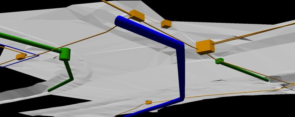
The task was to map all the subsurface utilities in Bakers Hill, WA – not a small undertaking! Main Roads WA needed this accurate information on the subsurface utilities in Bakers Hill WA to complete their design of a new road, in various formats, including from 12d Model.

Civil designers need their designs to work in the real world, and existing underground infrastructure can cause major issues. The existing records for the asset owners can be accessed through Dial Before You Dig (DBYD), but the spatial accuracy of these records is often not precise enough – in general there is a lot more underground than these records indicate, and the designers need data they can trust…enter subsurface utility locaters.

Dale Shearsmith’s team proceeded to locate all known Quality D utilities via Ground Penetrating Radar (GPR) and electromagnetic locaters. They then potholed for Quality Level A data.

SUI AS5488 (Classification of Subsurface Utility Information)

This Standard was prepared by Standards Australia Committee IT-036. The objective of this Standard is to provide utility owners, operators and locators with a framework for the consistent classification of information concerning subsurface utilities.

This Standard is intended to be used by those agencies and organisations that own, operate or regulate subsurface utility infrastructure and those that collect, depict and map such infrastructure. This Standard is also intended to be used by developers and consent authorities involved in the planning, approval and installation of subsurface utility infrastructure.

Subtera Methodology

To provide consistent data across projects, Subtera uses the following methodology

  • Take Quality Level C & D data and validate it to Quality Level A & B
  • Collate “As Constructed” drawings of the subsurface infrastructure
  • Ensure these utilities are located and surveyed
  • Search for “Unknown” subsurface utilities at the final stage
  • Every “Known” and “Unknown” utility will be accounted for in our field report providing an audit trail
  • We adhere to all asset owners regulations when accessing manholes and infrastructure and hold accreditions for ATCO High Pressure Gas, Telstra Fibre and the Watercorp
  • All works are carried out with a focus on Zero Harm to our employees and the public as outlined in our HSSE documentation

By delivering data to the AS5488 standard, the team was able to qualify the data with attributes, which flow through the design process, allowing Main Roads to accurately budget for asset relocations as well as trust the clash detections listed and integrate some of the utilities that were already there, allowing for more saving of money.
Download this Case Study as a PDF HERE
SPOT Training: Snippet Components using 12d Model 15

The Civil and Surveying Institute, the largest and most experienced provider of authorised 12d Model training courses, offers a range of training courses in different formats. This course is designed to be accessible to all 12d Model users. For the best learning experience, familiarity with the MTF is highly recommended, as the standard components are based on native MTF commands. While it is not required, completing the Civil Design Basics course beforehand will also give you a solid foundation and help you get the most out of the training.

Enrol in the entire course for only $250(AUD) excl GST

This Self-Paced Online Training course includes 3 hours 40 minutes of on-demand video training, allowing you to learn at your own pace with structured guidance.

As a part of the course, trainees access:

• 12d Model 15 licence for 3 months

• 23 tailored video lessons

• Full lifetime access to the 12d Model training content

• Practical and engaging quizzes

• Certificate of Completion

This course introduces the power of Snippets in 12d Model through the graphical user interface in the Snippet Components panel, showing how they can make design work faster, more flexible, and more efficient than traditional methods. You’ll learn how the MTF Snippet Apply, Snippet Manager, and Snippet Components work together to quickly create snippets and multiple Apply MTF Functions using reference strings, MTF seed files, and snippet parameters. The course also takes you through building a complete road snippet from scratch, combining familiar MTF commands with custom components to create road surfaces, table drains, batter benching, pavement layers, and other design elements directly from a cross-section.

You’ll also develop practical skills for managing more advanced snippet requirements, including the use of Parameters, Tokens, and Link Variables, customised chainages, conditional logic, and complex sub-layers. The course covers automatic parameters for retrieving project attributes and publishing custom attributes to support BIM compliance, as well as techniques for managing layer conflicts. To help you work confidently with and troubleshoot snippets, you’ll also learn how to encrypt and protect your snippets, structure workspaces effectively, interpret parsing logs, and use MTF flattening to identify and resolve errors.

Enrol Today: Civil and Surveying Institute. Self-Paced: Snippet Components – 12d Model 15

Piritahi’s Role in NZ’s Largest Urban Regeneration Project: Transforming Design with 12d Model

Piritahi is a large scale construction alliance in Auckland, New Zealand, delivering the civil engineering and infrastructure needed to support thousands of new state homes. Working for Kāinga Ora, Piritahi is undertaking one of New Zealand’s largest urban regeneration programmes, a five year, approximately NZ$1 billion programme spanning around 52 square kilometres across six established Auckland neighbourhoods. The project involves replacing ageing infrastructure and enabling the redevelopment of thousands of state homes, all while working within complex brownfield environments and around existing homes, services, roads and residents.

With a project of this scale, effective collaboration and data management are essential. 12d Model and 12d Synergy have played a key role in helping Piritahi manage the volume and complexity of its design, survey and construction information. 12d Model has been used across multiple disciplines to develop 3D designs for roads, stormwater and sewer networks, existing services and intersections, while also integrating with GIS platforms, Revit, XP SWMM, 3D scanning and drone survey data. 12d Synergy provides a central platform for around 500 users across the alliance, enabling teams to securely access, manage and collaborate on project information from anywhere. Its cloud-based setup became particularly valuable during COVID 19 lockdowns, allowing teams to continue working remotely while maintaining a single source of truth and a clear audit trail.

Together, these digital tools have helped Piritahi create a more connected and efficient approach to design, construction and data management. From 3D modelling and clash detection to GIS visualisation, augmented reality and construction survey data, information can be shared between teams and fed back into the design process. By using technology to support collaboration throughout the project lifecycle, Piritahi is not only helping to deliver complex infrastructure more efficiently but also contributing to a broader goal: creating safe, warm and dry homes for communities across Auckland.

SPOT Training: BIM – 12d Model 15

Take your 12d Model skills further with our 12d Model 15 BIM Course, designed for users who want to develop practical BIM workflows and create flexible, information-rich models that support modern project requirements.

For only $200 AUD excl. GST, you’ll get access to 6 hours and 19 minutes of self-paced video training, allowing you to work through the lessons at your own pace with structured guidance and practical exercises.

What You’ll Get

Your enrolment includes everything you need to work through the course, including:
Certificate of Completion upon successfully completing the course
-12d Model 15 software licence and course data
– A 12d Model 15 Cloud licence provided free for three months
20 online video lessons
– Practical and engaging quizzes
12 months’ access to the SPOT video lessons

If you’re taking the course simply to practise and improve your 12d Model skills, certification is optional.

The BIM course builds on the concepts introduced in 12d Model 15 – Getting Started for Utility Modelling, particularly object creation and attribution, which form an important foundation for many BIM workflows.

Completing the Getting Started for Utility Modelling course is recommended before beginning this course. The course is available free with SPOT and is also included when registering for the BIM course.

What Will You Learn?

Throughout the course, you’ll explore a range of advanced BIM-driven workflows in 12d Model, with a strong focus on object creation, attribute management, automation and data coordination.

BIM Object Creation and Application

Learn how to create and apply a variety of BIM objects, including:

  • Fences
  • Trenching
  • Guardrails
  • Linemarking
  • Handrails
  • Traffic lights

Water Strings and Data Export

Explore water strings and their associated workflows, including:

  • Attribution
  • Exporting to IFC
  • Converting to super strings and trimeshes

Clash Detection

Develop practical skills in identifying potential conflicts within your model by:

  • Creating new clash rules
  • Running clash detection between super strings, trimeshes and TINs

Signage

Learn how to work with signage data by:

  • Creating signage from survey data
  • Creating your own signs

MetaConnex

Explore the capabilities of MetaConnex, including:

  • MetaConnex Function Calls
  • MetaConnex with Custom Attributes
  • Practical MetaConnex examples
  • Attribute validation

Pavements

The course also covers BIM-driven pavement workflows, including:

  • Attribute management
  • Pavement creation using the MTF
  • Creating pavements from TINs
  • Creating subgrade TINs from trimeshes

Flexible, Self-Paced Learning

This is a Self-Paced Online Training course, giving you the flexibility to learn when and where it suits you. With more than six hours of on-demand video content, you can pause, revisit and practise each workflow as you progress.

For the best learning experience, dual monitors are recommended—use one screen to follow the training videos and the other to complete the course exercises. Alternatively, you can use a second computer.

All you need is a reliable internet connection and access to the provided 12d Model 15 Cloud licence.

Certificate of Completion

Students who successfully complete the course can receive a Certificate of Completion. The certificate is designed to encourage students to work through the full course and does not include a grade or specify a number of credit hours that could influence employment or promotions.

If you’re completing the course purely to strengthen your 12d Model skills, you can choose to undertake the training without pursuing certification.

Start Developing Your BIM Skills

Whether you’re looking to strengthen your existing 12d Model knowledge or develop more advanced BIM workflows, this course provides practical training in creating, attributing, coordinating and managing information-rich project data.

Enroll in the complete course for only $200 AUD excl. GST and work through the training at your own pace with access to the course content for 12 months.

Enroll here today: Civil and Surveying Institute. Self-Paced: BIM – 12d Model 15[Limited Time Offer]

The Tipster: 12d Master Shares with 12d Synergy

Master Shares provide a practical way to share models and TINs between projects when using 12d Model with 12d Synergy. To access the Master Share Manager, go to Project > Sharing > Share Manager, or use the sharing toolbar. Before creating a Master Share file, the required models and TINs must first be made available for sharing. This can be done through the Share Manager or through the Share Models Out and Share TINs Out options. Once the required data has been selected, save the changes and check in the project through Project > 12d Synergy > Check-in Project so the updated sharing information is synchronised with the Synergy server.

When creating a Master Share file, use the Share Out tab and select Add New Master Share. It is recommended to store Master Share files in a dedicated Master Shares folder rather than inside individual working projects. This makes the files easier for users to locate and manage, particularly in a Synergy environment where projects are regularly checked in and out. When adding the source project, 12d Synergy users should select Access by 12d Synergy Data Management Server and browse to the required project. Avoid selecting Store Relative Path, as this can cause the Master Share to reference workspace data rather than the Synergy-managed project data. For easier management, it is also recommended to use one project per Master Share file, even though multiple projects can be included.

To add a Master Share to another project, go to the Share In tab and select Add New Master Share. Browse to the dedicated Master Shares folder, select the required file and save it to synchronise the data. The models and TINs included in the Master Share can then be added to the project. Once a project is subscribed to a Master Share, any additional models or TINs added by the Master Share owner will become available after the next synchronisation. This provides an efficient way of keeping shared project data up to date without manually transferring individual files between projects.

The Master Share logging and status information is also a useful tool for checking that data is being referenced correctly. A green status indicates that everything is working correctly, while orange indicates a warning and red indicates an error. When using 12d Synergy, users should check that the Master Share is referencing a Synergy path. If a local or workspace path is displayed instead, the Master Share may not have been shared correctly through Synergy, potentially resulting in outdated data or synchronisation issues. The logging information can also be expanded to identify the source file, models and TINs included, while options such as Edit File and Explore Folder can help users investigate and troubleshoot Master Share issues.

Watch the video here:

The Tipster: Master Shares V15

Master Shares in 12d Model 15 provide a convenient way to share and synchronise models and TINs across multiple projects. They allow you to create a central Master Share file containing selected project data, subscribe other projects to that file, and keep shared data consistent without having to manually copy files between projects.

In this guide, we’ll walk through the process of creating a Master Share file, adding models and TINs from multiple projects, subscribing a project to a Master Share, and finally unsubscribing or binding shared data into a project. Whether you’re sharing data from a single project or bringing together information from several projects, Master Shares provide a simple and efficient way to manage shared project data.

Watch the video here:

SPOT Training: ALDE Introduction to Land Development Design using 12d Model 15

The Civil and Surveying Institute (the largest and most experienced provider of authorised 12d Model training courses) offers a variety of training courses in multiple formats. In partnership with the Association of Land Development Engineers (ALDE), this Self-Paced Online Training (SPOT) course is designed for those starting out, transitioning to, or upskilling in the Land Development industry.

Enrol in the entire course for $2,000 (AUD) excl GST. $1,500 for ALDE members excl GST.

This Self-Paced Online Training course includes 36 hours and 33 minutes of on-demand video training, allowing you to learn at your own pace with structured guidance.

As a part of the course, trainees access:

ALDE Unit 1 – Introduction to Land Development Design (0:13:55)

ALDE Unit 2 – Road and Finished Surface Design (21:04:58)

ALDE Unit 3 – Stormwater Design (15:14:43)

– 12d Model Software licence for 12 months, and data

– Practical and engaging quizzes

– Certificate of Completion

The ALDE Introduction to Land Development Design Course provides a comprehensive learning experience, combining practical industry guidance with hands-on 12d Model training. The course includes the ALDE Land Development Design document, which covers typical land development procedures, key input documents and standards, Functional Layout Plan submissions, and advanced design theory and scheduling. Participants also receive access to a 12d Model training licence for the duration of the course, along with more than 100 industry-tailored training videos aligned with authority requirements such as EDCM, Melbourne Water, and AustRoads.

The course also provides in-depth training in key 12d Model design areas, including Road and Finished Surface Design and Stormwater Design. Topics covered include survey data preparation, super alignment design, stormwater coordination, lot grading, pavement design, stormwater networks, catchment assignment, Rational Method hydrology, pipe grading and sizing, services, gap flow calculations, and outputs and plotting.

Enrol Today: Civil and Surveying Institute. Self-Paced: ALDE Introduction to Land Development Design – 12d Model 15

The Tipster: Mark-Up and Review Tools

The 12d Tech Forum 2024 Directors Cut webinar series highlights valuable technical content that could not be fully included in the original face-to-face event. One featured session focused on the markup and review tools available in 12d Model 15 and 12d View 15, presented by Dalin Ve, Regional Sales Manager for 12d. The session demonstrated how these tools provide a digital alternative to traditional manual review processes while supporting existing quality assurance (QA) and BIM workflows across design, construction, and survey projects.

The markup and review tools were developed to improve collaboration, accountability, and traceability throughout project workflows. Available in both 12d Model and 12d View, the tools allow designers, reviewers, and field teams to review data without requiring every user to have a full 12d Model license. Each markup or review automatically records important information, including who created it, when it was issued, who is responsible for changes, the progress of those changes, and whether the completed work has been verified. This information is stored as object attributes, ensuring that review data remains connected to the project information throughout the process.

The webinar introduced three key components of the system: markup tools, 2.5D review tools, and true 3D review tools. The markup tools provide a familiar approach for drawing-based reviews, allowing users to create digital annotations such as rectangles, lines, text, revision clouds, and pointers. The 2.5D review tools are designed for digital workflows, enabling users to identify issues through smart review areas that capture comments, dates, and user information. The 3D review tools take collaboration further by allowing users to pinpoint issues spatially with X, Y, and Z coordinates, making them valuable for BIM coordination and federated model reviews.

A major advantage of the tools is the built-in workflow tracking system, which uses status gateways to manage progress from creation through verification. Reviews move through defined stages, including unassigned, in progress, completed, and verified, ensuring that changes are properly managed and documented. Additional features such as publishing, importing review data, view favorites, status tables, and HTML reporting help teams share information efficiently, prepare for meetings, and maintain clear records of project decisions. By combining digital markups, automated tracking, and BIM-ready data management, 12d Model 15 provides a flexible solution for improving quality control across the entire project lifecycle.

Watch the video here:

The City of Newcastle’s Rapid Digital Transformation During COVID-19 with 12d Synergy Case Study

How Did the City of Newcastle Achieve Rapid Digital Transformation During COVID-19 with 12d Synergy?

The City of Newcastle’s journey with 12d Synergy is a story of rapid transformation driven by opportunity and necessity. A series of organisational changes—including new leadership, modern design tools, a technology-enabled workplace, and flexible working practices—created the foundation for a digital shift that would reshape how the engineering team worked.

When COVID-19 forced the team to work remotely, managing large engineering datasets became an urgent challenge. 12d Synergy provided the solution, enabling the City of Newcastle to maintain productivity with secure data management, faster file access, version control, and seamless collaboration. Remarkably, the platform was implemented across the design and survey teams within just four weeks.

What started as a response to remote working evolved into a long-term transformation. Through phased adoption, the City expanded its use of 12d Synergy for project data management, email organisation, task tracking, and collaboration. The result was a more connected, efficient, and future-ready approach to managing engineering projects.

History Files: 12d helps rebuild Christchurch

As a key contractor within the Stronger Christchurch Infrastructure Rebuild Team (SCIRT), SCIRT (https://scirtlearninglegacy.org.nz/) leveraged 12d Model to help deliver one of New Zealand’s largest post-earthquake infrastructure reconstruction projects, restoring critical roads, water networks, and essential services across Christchurch.

The $2 billion rebuilding of Christchurch is one of the biggest and most complex civil engineering projects New Zealand has ever seen.

The city was hit by four major earthquakes over 10 months, the magnitude 6.3 quake in February 2011 being the most destructive.

The earthquakes resulted in the loss of 181 lives, and caused unprecedented damage that left the 376,000 residents without even basic infrastructure and services.

The massive rebuild task has started, and the design teams at work on restoring the devastated infrastructure needed to choose the right civil software.

They chose 12d Model — because it provides the best integrated package for surveying, preliminary and detailed design, construction and producing as-built drawings.

The project is being carried out by the Stronger Christchurch Infrastructure Rebuild Team (SCIRT), an alliance involving Christchurch City Council, Canterbury Earthquake Recovery Authority (CERA), New Zealand Transport Agency (NZTA), City Care, Downer, Fletcher Construction, Fulton Hogan, and MacDow New Zealand. It will also see major involvement from GHD, URS, Sinclair Knight Merz, Beca Opus and Eliot Sinclair.

And 12d Model will be helping the SCIRT teams across the alliance tackle a huge amount of work, in a project that will take at least five years.

An estimated $2.5 billion worth of replacements or repairs are needed to more than 200km of roads and 800km of pipes for water, wastewater and stormwater, as well as a large number of water reservoirs, bridges and public parks.

“12d Model is being used as the civil engineering database and for all the civil engineering functions including the surveying, drainage and sewer design and road design,” 12d Solutions Managing Director Lee Gregory said.

To help with the vast rebuild effort, 12d NZ are currently conducting “train the trainer” courses for drainage and civil design, and training for the SCIRT 12d Lead Designers.

“All the surveying is being done for SCIRT by consultants using 12d Model,” he said.

New Zealand government Earthquake Recovery Minister, Gerry Brownlee, said Canterbury had been amazingly resilient over recent months, with residents willing to make changes to meet the challenges of the devastated areas.

“Through earthquakes and snowstorms the city is still getting up and going to work,” Mr Brownlee said.

“Despite all they‘ve been through I believe confidence is growing among Cantabrians, and with good reason.”

Download this Case Study as a PDF HERE