For the North Kiama Bypass project in New South Wales, Australia, RMS NSW, with Project Design Supervisor John Burns, utilised 4D Model to rapidly develop an award-winning interactive presentation that supported planning approvals, enabled real-time design evaluation, and showcased the power of digital modelling in complex transport infrastructure projects.
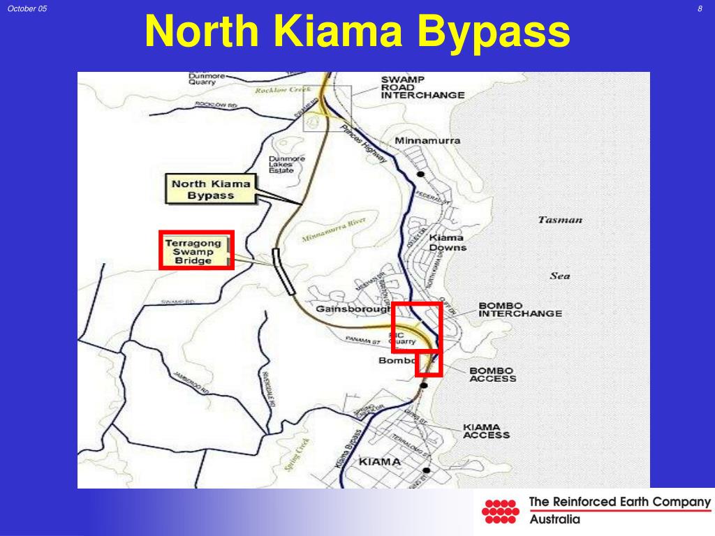
A presentation on the proposed North Kiama bypass, developed by the RTA (Roads and Traffic Authority) Wollongong’s Technology Branch using 4D Model civil and surveying software, has won an RTA Technology Merit Award for outstanding achievement. The presentation, using a laptop computer and overhead screen, was produced for the Commission of Inquiry into the bypass and according to John Burns, Project Design Supervisor, RTA Wollongong, it was received extremely well by all present.
“And what was even more pleasing was that the whole presentation was developed in under four weeks to meet a very tight deadline,” said Mr Burns.The North Kiama bypass project had been going on for around 10 years, due largely to the fact that it impacted on an environmentally-sensitive wetlands area. The local council had refused to approve the project, so it had to be put in front of a public hearing, or Commission of Inquiry, in order to gain State Government approval. The RTA received notification that the Commission of Inquiry would take place in six weeks time.
“We had to decide in a hurry how we would prepare our presentation,” said Mr Burns. “We had to come up with something which could be done quickly but which would be accurate and also be ’live’ so that we could answer ’what-if’ questions on the spot.
“We were long-term users of Moss for road design work,” he said. “It’s a good design tool but not one which you can use for quick and accurate concept work, which was what was needed as we had to present the Commission with options for the bypass route.”We had seen 4D Model previously, so knew it was exactly what we needed to do such a job in a hurry. To make sure it could be done, we asked Lee Gregory from 4D Solutions to come down and carry out an on-site demonstration of the capabilities of 4D Model.
“We then produced a quick business plan submission and obtained approval to purchase the software. It was installed quickly but by now we only had four weeks left to go until the Commission of Inquiry. We knew that, with such an extremely tight time-frame, we would not have time to train-up on 4D Model ourselves, but we had a competent operator elsewhere in the RTA in the form of Ray Tester from our Wagga Wagga office, who was a very experienced 4D Model user. Ray was seconded, on a part-time basis, to help us out, and things got underway,” said Mr Burns.
The initial steps for the RTA were to obtain digitised contour maps of the area, plus cadastral information and aerial photographs to locate and define vegetation limits and sensitive wetland areas. This information was used to start building up layers using Microstation to create the base model. This base model was then put into 4D Model and detailed concepts, interchange layouts, earthworks, boundary details and options were established.
“We wanted to be prepared from the first day of the Commission to be able to answer any design questions and present alternatives for the Commissioner, the members of public and the RTA personnel present, in a quick, accurate format,” said Mr Burns. “With 4D Model we were able to do this very quickly and present the updated information on screen.
“Everyone was very impressed with the speed and quality of the presentation,” he said. “4D Model also allowed us to do a walk- and drive-through video presentation, which helped clarify everyone’s perceptions of what the bypass would look like and, we believe, helped with the final decision. Ray Tester’s skills in the use of 4D were crucial in the design and presentation of this project. He obviously did a great job, as not only was the reception at the Commission excellent, but we subsequently received the RTA Merit Award.
“We are, of course, still using 4D, and we now have two licences servicing 15 workstations,” said Mr Burns. “I can’t praise 4D enough and their product support is also great.
“We used to produce our initial concepts by hand from contour plans then go into Moss,” he said. “This was satisfactory for simple jobs but created problems with complex projects. Now we start with 4D Model and produce the horizontal and vertical geometry, earthworks and cross-sections then go into Moss for the final design, and we obtain a much better result. We are currently investigating the purchase of software which will enable us to scan ortho/topo maps, build up a 3D model from this and then use 4D to produce an electronic, instead of a hand-produced, concept,” he said. “Then we’ll see an even bigger improvement”
Download this Case Study as a PDF HERE.