History Files: Engineering the Auxiliary Spillway at Warragamba – SMEC

In collaboration with the Sydney Catchment Authority, SMEC harnessed the capabilities of 4D Model (now 12d Model) to design and deliver key components of the Warragamba Dam Auxiliary Spillway project, enhancing design accuracy, visualisation, and earthworks management for a major infrastructure upgrade.

The major source of Sydney’s water supply is Warragamba Dam. Australia’s fourth largest dam, its primary function is to provide a water supply for the Sydney Metropolitan area. When adequate quantities of water are stored to meet these needs, electricity is generated and fed into the NSW grid by the hydro-electric power station located at the base of the dam.

Warragamba Dam is in the High Incremental Flood Hazard category and to prevent overtopping of the dam in extreme flood events, an auxiliary spillway is being constructed adjacent to the dam to divert floodwaters in excess of the capacity of the existing spillway.

The auxiliary spillway is a major civil engineering project due for completion in mid-2001. The works are being undertaken on a design and construct basis for the Sydney Catchment Authority (previously known as the Sydney Water Corporation) to improve the safety of the dam. In December 1998, the contract for the design and engineering of the spillway was awarded to SMEC, the Snowy Mountains Engineering Corporation.

The project involves major excavation – some 1.8 million cubic metres of sandstone and overburden is being removed and transported to a spoil emplacement – and the concrete lining of the auxiliary chute spillway which will be approximately 650 metres long and drop 50 metres before discharging to the river.

Five fuse plugs – embankments that are designed to wash away when overtopped – are being built at the upstream end of the spillway chute to prevent the auxiliary spillway from operating in flood flows smaller than about a one in 750 chance of occurrence in any year.

Generally, the floor and wall of the spillway chute are in the form of a reinforced concrete lining against the excavated rock surface, however, one section of the spillway over an existing creek line will be constructed on compacted fill with cantilever walls on either sides. A bridge across the spillway, and a new road, are designed to provide access to the crest of the dam, the Valve House and the hydro-electric power station at the base of the dam.

Following concept design carried out by the Department of Public Works and Services, SMEC is responsible for the development of the detailed design – from concept to production of construction drawings. A vital component in SMEC’s engineering design work is 4D Model (later renamed 12d Model) software. Design draftsman on the project, Michael Kurtz, says it contains all the options necessary to produce a digital terrain model (DTM), including fast triangulation, contouring and sectioning routines, and to calculate spill volumes for accurate placement and subsequent costing of the work carried out.

Warragamba Project Manager, John Gray, said 4D Model software was primarily used for design and modelling of the auxiliary spillway and associated access structures such as roads and the bridge approach, along with calculation of spill volumes.

“Using 4D allows us to continually modify designs,” Michael said, “and, most importantly, to do it quickly. 4D allowed us to complete re-designed versions very fast for presentation to the client and to show the designs interactively in plan and sectional views. We also had to continually modify the design to fit the spoil emplacement within specified confines nominated by the client. The spoil would not fit into the area initially defined and required many modifications of the design.

“The perspectives we can provide using 4D are an easy way to convey a design to people who find engineering plans and contours difficult to interpret,” Michael said. SMEC uses the 4D alignment module to construct strings consisting of horizontal and vertical geometry. These horizontal and vertical components are created and edited interactively using the IP method on plan and section views.

SMEC is also using the 4D Drainage Module in the Warragamba project. This module supports the display of drainage networks typically required for development projects and new land subdivisions. An added bonus SMEC encountered using 4D was the ease with which the model output could be checked at any stage of the design process.

Following development of a design component, a copy of the model was produced for checking and further development by design engineer, Tim Loffler. Tim, who had no previous training in the software, said he found it “a most intuitive package” and that he could view and interrogate the model after getting a feel for the way in which the program operates.

“The program is very robust and will faithfully do what you ask it to do,” he said.

Download this Case Study as a PDF HERE.

History Files: 12d Takes to the Beach – Cardno (now Stantec)

Cardno MBK now Stantec, in partnership with Consolidated Properties Pty Ltd and contractor Robbie Marshall, leveraged the capabilities of 12d Model to successfully deliver the large-scale Casuarina Beach development in Australia while meeting demanding project timelines and complex design requirements.

12d Model was integral to the success of the Casuarina Beach project, allowing Cardno MBK (CMBK) to meet extremely tight deadlines by reducing the huge variety of calculations required on a project of this magnitude. One of the last ‘absolute beachfront’ sites earmarked for development on the Northern NSW Coast, Casuarina Beach will ultimately be home to more than 5000 people.

The development is the project of Consolidated Properties Pty Ltd, a Brisbane-based firm primarily involved in commercial developments. The supply of all engineering and environmental services was contracted to Cardno. The joint project is being developed by CMBK’s Gold Coast office and its Environmental Unit.

The Gold Coast office was charged with completing the designs, obtaining all Tweed Council and Authority approvals, and supervision of the construction for the infrastructure of over 400 lots and tourist resort sites, to be ready for release by mid-2001.

To achieve these deadlines, CMBK had to rely on creativity and innovation, along with the integration of advanced technology with responsive management. CMBK had successfully used 12d Model for earthworks and civil design on the Seabreeze Estate subdivision at Pottsville. The company was then confident in selecting 12d Model for the Casuarina Beach development.

As Civil Designer at CMBK, Robbie Marshall stated: “Software packages such as 12d greatly assist in meeting deadlines. The diversity and speed of 12d significantly reduced the huge variety of calculations required on a project of the magnitude of Casuarina.”

For the duration of the project, CMBK’s Gold Coast office was primarily involved in the engineering design of roadworks, drainage and trunk water mains; the design of over 4km of 200mm diameter sewer rising main; design and reporting on stormwater drainage systems for the overall development, adopting infiltration basins to complement piped and open channel drainage mechanisms; design of a sewerage reticulation system incorporating a regional pump station to benefit Casuarina Beach and adjacent developments.

The 12d Model modules catered for specific tasks involved in these functions, including such capabilities as the alignment module which uses cross-section templates and string design methods to produce roads, canals and other linear earthwork models. Cut and fill volumes are automatically produced for the design.

When adjustments are made to the alignment strings or templates, the 12d Model recalc option automatically removes invalid information and replaces it with the updated geometry and volumes.

According to Robbie Marshall, this is particularly useful when designing roads, swales, storage ponds or any situation where a number of trials are needed to determine the best position for final alignment. The drainage module supports the display of drainage networks, typically those required for new land subdivisions and development projects such as Casuarina Beach. The drainage string itself consists of manholes, joined by straight or curved pipes. Invert levels and pipe grades can be set or modified graphically or by typed input. Manhole and pipe sizes are also user definable.

Robbie explained that earthwork volumes for trenches can be calculated along the selected design line. “The bulk earthworks modelling for Casuarina was carried out using 12d,” he said. “It was an immense task over the 38-hectare site but was significantly simplified using the software.”

Use of the Volumetrics and TIN Analysis capabilities allows calculation of earthworks volumes within a user defined polygon using either end area or exact calculations. Reports of cut and fill areas and volumes are given on a section-by-section basis using the end area method or on a depth basis using prismodial volumes. Depth volumes can be colour coded for validation and plots.

The integration of these features has allowed CMBK to meet its selection criteria. Robbie explained that CMBK wanted to “increase productivity without reducing quality in the design and documentation of urban developments and civil infrastructure projects”.

Highlighting specific features which CMBK found particularly valuable, he cited the increase in speed of road designs due to the fact that preliminary designs could be simply recalculated with the use of template files; time saved using the kerb function; and the string-based design software which allows accurate finish profiles to be obtained.

He added that the software has good interaction with other packages and was easy to learn and to use, even for the non-computer literate.

Download this Case Study as a PDF HERE.
History Files: 12d Model Provides Land and Sea Data for Fisherman Islands

Port of Brisbane logo

At Port of Brisbane Corporation in Queensland (https://www.portbris.com.au/), the versatility of 12d Model was showcased through its critical role in dredging, terrain modelling, and infrastructure design for the landmark Fisherman Islands expansion project.

4D Model (later renamed 12d Model) software is proving to be equally at home on water as it is on land.

The Port of Brisbane Corporation is proving the flexibility of 4D Model by using it for volume checking, contour checking and road design on its development at the Fisherman Islands.

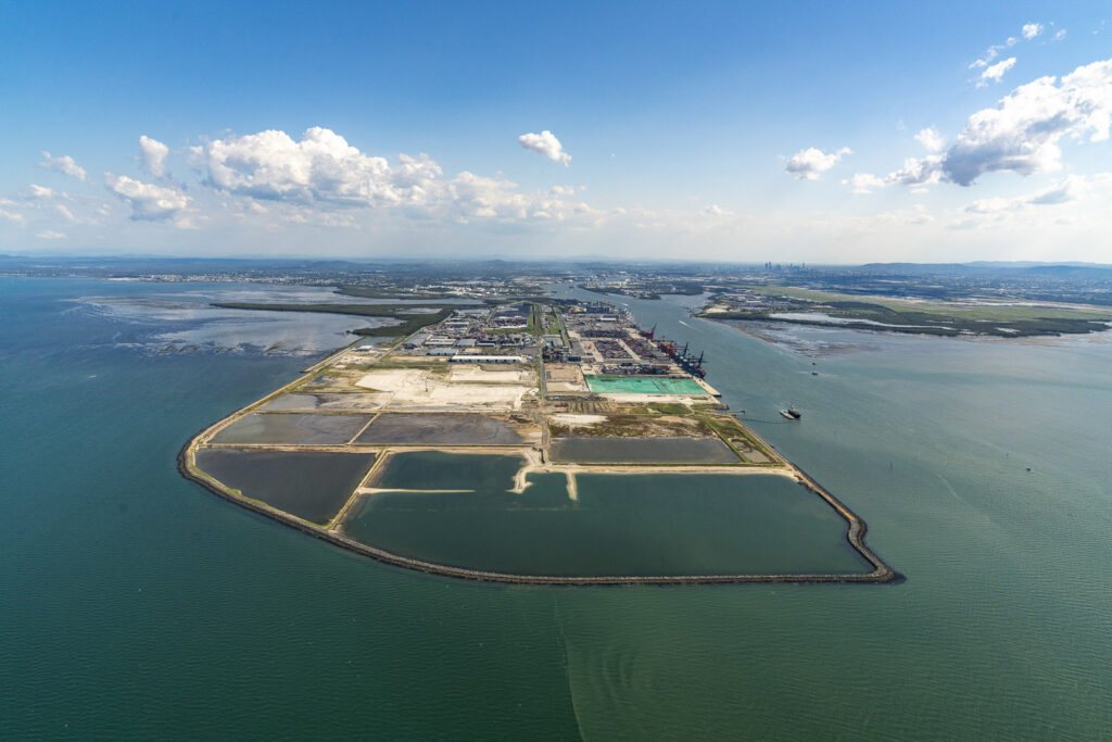
Fisherman Islands is located at the mouth of the Brisbane River. The area was a group of four islands which have been joined by reclamation. Over a 20-year period Fisherman Islands has been developed into one of the most modern container and bulk handling ports in the world.

The site has already out-grown its original land and future expansion has been provided for with the recent reclamation of more than 70 hectares using material dredged from the main access channels in Moreton Bay and the Brisbane River.

This reclamation involved moving 2.6 million cubic metres of sand using the Pearl River dredge which was contracted from Holland. The massive amount of material was to be shifted in 10 weeks.

4D Model was used to calculate pre- and post-dredge volumes. These volumes are used to measure the amount of sand moved and provide the data for the $16 million payment to the dredging contractors.

4D Model is also used to provide 3D views of the Brisbane River bed.

“4D Model provides us with dynamic views of the river bed which permit the observer to clearly understand its profile,” said a Port of Brisbane Corporation draftsman.

The nature of the work carried out by the Port of Brisbane Corporation highlights 4D’s use as a general purpose civil engineering tool. The software can effortlessly provide volume calculations for roading, dredging or landfills.

Engineering surveys are carried out by the Corporation’s surveyors using Total Station equipment. The surveyors process this data using Geocomp and send the resulting information by modem to a network of Digital workstations which run the Ultrix operating system and 4D Model.

“All that data is imported into 4D for checking contours, terrain modelling and volume calculations,” the draftsman said.

4D Model has also been used in the design of a service road network, as well as a major access road and an open drain on the Moreton Bay side of Fisherman Islands.

“The biggest benefit of 4D Model is its speed, accuracy and ease of use. It is powerful and can be programmed to do what you want it to do. The other very big factor is the local support; if you have a problem you can get it fixed very quickly.”

Port of Brisbane draftsmen said while 4D Model is not in use every day, the five members of the CAD unit can turn to it as required and quickly complete their work because of its easy-to-use graphical user interface.

Download this Case Study as a PDF HERE